
Topografische Karte Ikaria
Interaktive Karte
Klicken Sie auf die Karte, um die Höhe anzuzeigen.
Ikaria
Die größte Länge von nahezu 40 km erreicht Ikaria von Westsüdwest nach Ostnordost. Die Inselbreite beträgt zwischen 5,5 und etwa 8 km, die schmalste Stelle im Nordosten in der Nähe des Flughafens misst 1,5 km. Ikaria hat überwiegend gebirgigen Charakter mit zahlreichen Schluchten, aber auch eine Hochebene im Südwesten. Auf fast ihrer gesamten Länge wird die Insel vom Atheras durchzogen, der eine Höhe von bis zu 1.037 m erreicht. Dieser Bergzug teilt Ikaria in eine steilabfallende, unzugänglichere Südhälfte, während der Abfall zur Nordseite hin sanfter ist und bei Kambos und Faros in kleine, fruchtbare Küstenebenen übergeht. Der Küstenverlauf ist kaum gegliedert; er bietet einige Buchten, Ankerplätze oder natürliche Häfen.
Über diese Karte
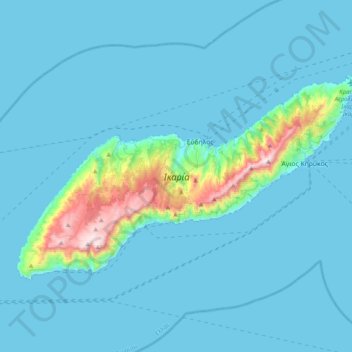
Name: Topografische Karte Ikaria, Höhe, Relief.
Durchschnittliche Höhe: 87 m
Minimale Höhe: 0 m
Maximale Höhe: 1.027 m
Andere topografische Karten
Klicken Sie auf eine Karte, um ihre Topografie, ihre Höhe und ihr Relief anzuzeigen.
Άγιος Παντελεήμονας
Griechenland > Ägäis > Regionalbezirk Ikaria > Agios Polykarpos
Durchschnittliche Höhe: 397 m