Geolokalisieren

Topografische Karte Chantilly

Interaktive Karte

Klicken Sie auf die Karte, um die Höhe anzuzeigen.

Über diese Karte

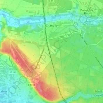
Name: Topografische Karte Chantilly, Höhe, Relief.

Ort: Chantilly, Senlis, Oise, Hauts-de-France, Metropolitan France, 60500, France (49.15660 2.44767 49.20335 2.52738)

Durchschnittliche Höhe: 61 m

Minimale Höhe: 31 m

Maximale Höhe: 116 m

Chantilly straddles the junction of the Paris Basin and the western County of Valois, of which the Nonette River is a boundary. The site of the town was originally a clearing or meadowland, sometimes called a lawn or pelouse, which is mostly occupied today by the racecourse. The remaining open space between the town and the racecourse is always referred to as the "little lawn". The highest point in the area, 112 meters (378'), is at Bois Lorris, in Lamorlaye. The lowest elevation is 35 metres (115'), at the Canardière on the banks of the Nonette in Gouvieux.

Wikipedia (CC-BY-SA 3.0)

Andere topografische Karten

Klicken Sie auf eine Karte, um ihre Topografie, ihre Höhe und ihr Relief anzuzeigen.

Glatigny

France > Hauts-de-France > Oise

Glatigny, Beauvais, Oise, Hauts-de-France, Metropolitan France, 60650, France

Durchschnittliche Höhe: 180 m

Saint-Paul

France > Hauts-de-France > Oise

Saint-Paul, Beauvais, Oise, Hauts-de-France, Metropolitan France, 60650, France

Durchschnittliche Höhe: 113 m

Ravenel

France > Hauts-de-France > Oise

Ravenel, Clermont, Oise, Hauts-de-France, Metropolitan France, 60130, France

Durchschnittliche Höhe: 117 m

Domfront

France > Hauts-de-France > Oise

Domfront, Clermont, Oise, Hauts-de-France, Metropolitan France, 60420, France

Durchschnittliche Höhe: 89 m

Verberie

France > Hauts-de-France > Oise

Verberie, Senlis, Oise, Hauts-de-France, Metropolitan France, 60410, France

Durchschnittliche Höhe: 68 m

Boulincourt

France > Hauts-de-France > Oise > Agnetz

Boulincourt, Agnetz, Clermont, Oise, Hauts-de-France, Metropolitan France, 60600, France

Durchschnittliche Höhe: 108 m

Creil

France > Hauts-de-France > Oise

Creil, Senlis, Oise, Hauts-de-France, Metropolitan France, 60100, France

Durchschnittliche Höhe: 61 m

Chambly

France > Hauts-de-France > Oise

Chambly, Senlis, Oise, Hauts-de-France, Metropolitan France, 60230, France

Durchschnittliche Höhe: 65 m

Saint-Crépin-aux-Bois

France > Hauts-de-France > Oise

Saint-Crépin-aux-Bois, Compiègne, Oise, Hauts-de-France, Metropolitan France, 60170, France

Durchschnittliche Höhe: 94 m

Offémont

France > Hauts-de-France > Oise > Saint-Crépin-aux-Bois

Offémont, Saint-Crépin-aux-Bois, Compiègne, Oise, Hauts-de-France, Metropolitan France, 60170, France

Durchschnittliche Höhe: 116 m

Saint-Félix

France > Hauts-de-France > Oise

Saint-Félix, Clermont, Oise, Hauts-de-France, Metropolitan France, 60370, France

Durchschnittliche Höhe: 81 m

Saint-Jean-aux-Bois

France > Hauts-de-France > Oise

Saint-Jean-aux-Bois, Compiègne, Oise, Hauts-de-France, Metropolitan France, 60350, France

Durchschnittliche Höhe: 95 m

Verneuil-en-Halatte

France > Hauts-de-France > Oise

Verneuil-en-Halatte, Senlis, Oise, Hauts-de-France, Metropolitan France, 60550, France

Durchschnittliche Höhe: 69 m

Pont-Sainte-Maxence

France > Hauts-de-France > Oise

Pont-Sainte-Maxence, Senlis, Oise, Hauts-de-France, Metropolitan France, 60700, France

Durchschnittliche Höhe: 56 m

Chiry-Ourscamp

France > Hauts-de-France > Oise

Chiry-Ourscamp, Compiègne, Oise, Hauts-de-France, Metropolitan France, 60138, France

Durchschnittliche Höhe: 54 m

Villers-Saint-Frambourg

France > Hauts-de-France > Oise > Villers Saint Frambourg-Ognon

Villers-Saint-Frambourg, Villers Saint Frambourg-Ognon, Senlis, Oise, Hauts-de-France, Metropolitan France, 60810, France

Durchschnittliche Höhe: 126 m

Ermenonville

France > Hauts-de-France > Oise

Ermenonville, Senlis, Oise, Hauts-de-France, Metropolitan France, 60950, France

Durchschnittliche Höhe: 101 m

Compiègne

France > Hauts-de-France > Oise > Compiègne

Compiègne, Oise, Hauts-de-France, Metropolitan France, 60200, France

Durchschnittliche Höhe: 54 m

Apremont

France > Hauts-de-France > Oise > Apremont

Apremont, Senlis, Oise, Hauts-de-France, Metropolitan France, 60300, France

Durchschnittliche Höhe: 83 m

Clermont

France > Hauts-de-France > Oise

Clermont, Oise, Hauts-de-France, Metropolitan France, 60600, France

Durchschnittliche Höhe: 77 m

Valescourt

France > Hauts-de-France > Oise > Valescourt

Valescourt, Clermont, Oise, Hauts-de-France, Metropolitan France, 60130, France

Durchschnittliche Höhe: 131 m

Bury

France > Hauts-de-France > Oise

Bury, Clermont, Oise, Hauts-de-France, Metropolitan France, 60250, France

Durchschnittliche Höhe: 80 m

Senlis

France > Hauts-de-France > Oise

Senlis, Oise, Hauts-de-France, Metropolitan France, 60300, France

Durchschnittliche Höhe: 80 m

Villers Saint Frambourg-Ognon

France > Hauts-de-France > Oise

Villers Saint Frambourg-Ognon, Senlis, Oise, Hauts-de-France, Metropolitan France, 60810, France

Durchschnittliche Höhe: 114 m

Bienville

France > Hauts-de-France > Oise

Bienville, Compiègne, Oise, Hauts-de-France, Metropolitan France, 60280, France

Durchschnittliche Höhe: 67 m

Noailles

France > Hauts-de-France > Oise

Noailles, Beauvais, Oise, Hauts-de-France, Metropolitan France, 60430, France

Durchschnittliche Höhe: 118 m