Topografische Karte Catania
Interaktive Karte
Klicken Sie auf die Karte, um die Höhe anzuzeigen.
Über diese Karte
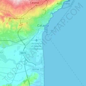
Name: Topografische Karte Catania, Höhe, Relief.
Ort: Catania, Sicily, Italy (37.35830 14.93587 37.56239 15.12579)
Durchschnittliche Höhe: 50 m
Minimale Höhe: -1 m
Maximale Höhe: 441 m
Around 263 BC, the city was variously known as Catĭna (Latin: [ˈkatɪna]) and Catăna (Latin: [ˈkatana]; Ancient Greek: Κατάνη [katánɛː]). The former has been primarily used for its supposed assonance with catina, the Latin feminization of the name catinus. Catinus has two meanings: "a gulf, a basin or a bay" and "a bowl, a vessel or a trough", thanks to the city's distinctive topography.
Andere topografische Karten
Klicken Sie auf eine Karte, um ihre Topografie, ihre Höhe und ihr Relief anzuzeigen.
Serro Calderaro
Italy > Sicily > Catania > Giumarra
Serro Calderaro, Giumarra, Castel di Iudica, Catania, Sicily, 95040, Italy
Durchschnittliche Höhe: 317 m
Zafferana Etnea
Zafferana Etnea, Catania, Sicily, 95019, Italy
Durchschnittliche Höhe: 771 m
Biancavilla
Biancavilla, Catania, Sicily, 95033, Italy
Durchschnittliche Höhe: 687 m
Mofeta dei Palici
Italy > Sicily > Catania > Mineo
Mofeta dei Palici, Mineo, Catania, Sicily, 95044, Italy
Durchschnittliche Höhe: 125 m
Etna
Italy > Sicily > Catania > Zafferana Etnea
Etna, Zafferana Etnea, Catania, Sicily, 95019, Italy
Durchschnittliche Höhe: 2.976 m