
Spenden
Rüsten Sie sich für Ihr nächstes Abenteuer:
Als Amazon-Partner verdient diese Website an qualifizierten Käufen, ohne dass Ihnen zusätzliche Kosten entstehen.
Topografische Karte Christmas Island
Klicken Sie auf die Karte, um die Höhe anzuzeigen.
Spenden
Rüsten Sie sich für Ihr nächstes Abenteuer:
Als Amazon-Partner verdient diese Website an qualifizierten Käufen, ohne dass Ihnen zusätzliche Kosten entstehen.
Christmas Island
Die Weihnachtsinsel liegt im Indischen Ozean, 350 km südlich von Java und 2616 km nordwestlich von Perth. Die Insel ist etwa 135 km² groß. Sie besteht aus einem vulkanischen Kern (Trachyt und Basalt) sowie Kalkstein, der aus den Skeletten von Kammerlingen (Foraminifera) und Steinkorallen (Scleractinia) entstanden ist. Sie erhebt sich aus einer Meerestiefe von mehr als 4000 m und ragt etwa 350 m über den Meeresspiegel. Der höchste Punkt ist der Murray Hill im Westen der Insel mit einer Höhe von 361 Metern. Die Küste ist schroff und schwer erreichbar. Ein erheblicher Anteil der Insel steht unter Naturschutz. 1980 wurde der 85 km² große Weihnachtsinsel-Nationalpark eingerichtet[1].
Spenden
Rüsten Sie sich für Ihr nächstes Abenteuer:
Als Amazon-Partner verdient diese Website an qualifizierten Käufen, ohne dass Ihnen zusätzliche Kosten entstehen.
Über diese Karte
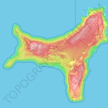
Name: Topografische Karte Christmas Island, Höhe, Relief.
Durchschnittliche Höhe: 69 m
Minimale Höhe: 0 m
Maximale Höhe: 363 m
Spenden
Rüsten Sie sich für Ihr nächstes Abenteuer:
Als Amazon-Partner verdient diese Website an qualifizierten Käufen, ohne dass Ihnen zusätzliche Kosten entstehen.