
Spenden
Rüsten Sie sich für Ihr nächstes Abenteuer:
Als Amazon-Partner verdient diese Website an qualifizierten Käufen, ohne dass Ihnen zusätzliche Kosten entstehen.
Topografische Karte Gangtok
Klicken Sie auf die Karte, um die Höhe anzuzeigen.
Spenden
Rüsten Sie sich für Ihr nächstes Abenteuer:
Als Amazon-Partner verdient diese Website an qualifizierten Käufen, ohne dass Ihnen zusätzliche Kosten entstehen.
Gangtok
Gangtok (Nepali/Hindi: गंगटोक, Gaṅgṭok anhören, Bhutia སྒང་ཐོག་ sgang thog) ist Hauptstadt und die größte und wirtschaftlich bedeutendste Stadt des ehemaligen Königreichs und jetzigen indischen Bundesstaates Sikkim. Sie liegt im Südosten des Bundesstaates auf den südlichen Ausläufern des Himalaya-Gebirges auf etwa 1800 Metern Höhe. In der Stadt leben 29.162 Menschen (Volkszählung 2001), sie ist das Zentrum des Tourismus in Sikkim und Verwaltungssitz des Distrikts East Sikkim.
Spenden
Rüsten Sie sich für Ihr nächstes Abenteuer:
Als Amazon-Partner verdient diese Website an qualifizierten Käufen, ohne dass Ihnen zusätzliche Kosten entstehen.
Über diese Karte
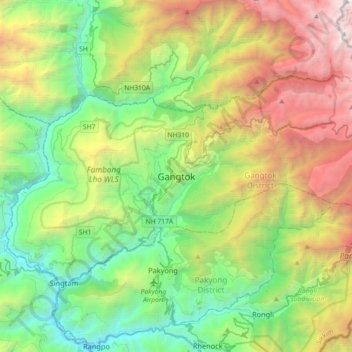
Name: Topografische Karte Gangtok, Höhe, Relief.
Ort: Gangtok, Gangtok subdivision, Gangtok, Sikkim, 737101, Indien (27.16905 88.45227 27.48905 88.77227)
Durchschnittliche Höhe: 1.911 m
Minimale Höhe: 283 m
Maximale Höhe: 5.193 m
Spenden
Rüsten Sie sich für Ihr nächstes Abenteuer:
Als Amazon-Partner verdient diese Website an qualifizierten Käufen, ohne dass Ihnen zusätzliche Kosten entstehen.