
Topografische Karte Awassa
Interaktive Karte
Klicken Sie auf die Karte, um die Höhe anzuzeigen.
Über diese Karte
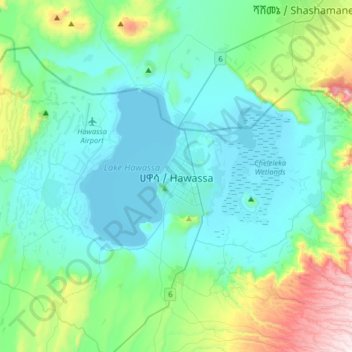
Name: Topografische Karte Awassa, Höhe, Relief.
Ort: Awassa, Sidama, 1923, Äthiopien (6.88810 38.31861 7.20810 38.63861)
Durchschnittliche Höhe: 1.862 m
Minimale Höhe: 1.682 m
Maximale Höhe: 2.632 m