
Spenden
Rüsten Sie sich für Ihr nächstes Abenteuer:
Als Amazon-Partner verdient diese Website an qualifizierten Käufen, ohne dass Ihnen zusätzliche Kosten entstehen.
Topografische Karte Taos
Klicken Sie auf die Karte, um die Höhe anzuzeigen.
Spenden
Rüsten Sie sich für Ihr nächstes Abenteuer:
Als Amazon-Partner verdient diese Website an qualifizierten Käufen, ohne dass Ihnen zusätzliche Kosten entstehen.
Taos
Taos ist eine Gemeinde mit dem Status einer Town in New Mexico, USA auf 2124 m Höhe am Fuß der Sangre de Cristo Mountains. Der Ort liegt im Tal des Rio Grande und rund 70 Meilen (rund 113 km) nordnordöstlich von Santa Fe und Los Alamos. Taos hat 5716 Einwohner (US Census 2010) und ist Sitz der Countyverwaltung (County Seat des Taos County).
Spenden
Rüsten Sie sich für Ihr nächstes Abenteuer:
Als Amazon-Partner verdient diese Website an qualifizierten Käufen, ohne dass Ihnen zusätzliche Kosten entstehen.
Über diese Karte
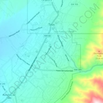
Name: Topografische Karte Taos, Höhe, Relief.
Durchschnittliche Höhe: 2.180 m
Minimale Höhe: 2.066 m
Maximale Höhe: 2.739 m
Spenden
Rüsten Sie sich für Ihr nächstes Abenteuer:
Als Amazon-Partner verdient diese Website an qualifizierten Käufen, ohne dass Ihnen zusätzliche Kosten entstehen.