
Topografische Karte Valencia
Interaktive Karte
Klicken Sie auf die Karte, um die Höhe anzuzeigen.
Valencia
Die Fallas beginnen mit Anfang März und erreichen am 14./15.–19. März ihren Höhepunkt. Sie werden mit Umzügen durch die Stadtviertel in traditioneller Tracht, Festessen und Feuerwerken gefeiert. Es gibt zwei verschiedene Kategorien von Feuerwerken: das eine sind die mascletàs die täglich um 14 Uhr in allen Fallas stattfinden; die mit Abstand größte ist die von der Stadt organisierte Mascletá auf der Plaça de l’Ajuntament. Das andere sind die Castillos de fuegos artificiales die in den vier Nächten vor dem 19. März in den Nachthimmel geschossen werden. Das wichtigste und eindrucksvollste ist die nit del foc (span. noche del fuego/Nacht des Feuers) in der Nacht vom 18. auf den 19. März. Am 17. und 18. März werden der Virgen de los Desamparados mit Umzügen Blumen dargeboten (ofrenda). Die Blumen werden vor der Basilika auf der Plaça de la Virgen zu einem 10 Meter hohen Marienbild zusammengesteckt. In der Nacht vom 19. zum 20. März werden die fallas-Figuren in einem Akt namens cremà verbrannt.
Über diese Karte
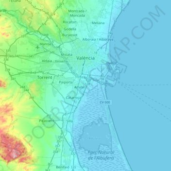
Name: Topografische Karte Valencia, Höhe, Relief.
Durchschnittliche Höhe: 37 m
Minimale Höhe: -6 m
Maximale Höhe: 346 m