
Topografische Karte Breckenridge
Interaktive Karte
Klicken Sie auf die Karte, um die Höhe anzuzeigen.
Über diese Karte
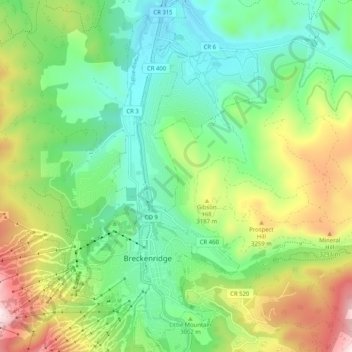
Name: Topografische Karte Breckenridge, Höhe, Relief.
Durchschnittliche Höhe: 3.072 m
Minimale Höhe: 2.802 m
Maximale Höhe: 3.809 m
At the 2020 United States Census, the town had a total area of 6.047 square miles (15.661 km2), all of it land. The ski area has a total area of 2,880 acres (11.7 km2) of land. The elevation of Breckenridge is 9,600 feet (2,900 m) above sea level.
Andere topografische Karten
Klicken Sie auf eine Karte, um ihre Topografie, ihre Höhe und ihr Relief anzuzeigen.
Silverthorne
United States > Colorado > Summit County
Silverthorne, Summit County, Colorado, 80497, United States
Durchschnittliche Höhe: 2.858 m
Keystone
United States > Colorado > Summit County
Keystone, Summit County, Colorado, 80435, United States
Durchschnittliche Höhe: 3.300 m
Bald Mountain
United States > Colorado > Summit County
Bald Mountain, Summit County, Colorado, United States
Durchschnittliche Höhe: 3.733 m
Blue River
United States > Colorado > Summit County
Blue River, Summit County, Colorado, United States
Durchschnittliche Höhe: 3.075 m
Dillon
United States > Colorado > Summit County > Silverthorne
Dillon, Silverthorne, Summit County, Colorado, United States
Durchschnittliche Höhe: 2.796 m
Frisco
United States > Colorado > Summit County
Frisco, Summit County, Colorado, United States
Durchschnittliche Höhe: 2.835 m
Silverthorne
United States > Colorado > Summit County
Silverthorne, Summit County, Colorado, 80497, United States
Durchschnittliche Höhe: 2.883 m