
Topografische Karte Gombak
Interaktive Karte
Klicken Sie auf die Karte, um die Höhe anzuzeigen.
Über diese Karte
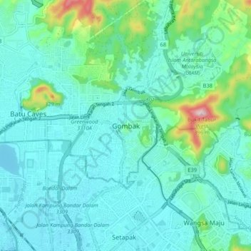
Name: Topografische Karte Gombak, Höhe, Relief.
Durchschnittliche Höhe: 94 m
Minimale Höhe: 35 m
Maximale Höhe: 386 m
Andere topografische Karten
Klicken Sie auf eine Karte, um ihre Topografie, ihre Höhe und ihr Relief anzuzeigen.
Kampung Desa Kuala Garing
Malaysia > Selangor > Selayang Municipal Council > Rawang
Durchschnittliche Höhe: 35 m
Kampung Melayu Wira Damai
Malaysia > Selangor > Selayang Municipal Council > Batu Caves
Durchschnittliche Höhe: 91 m
Sungai Pajam
Malaysia > Selangor > Selayang Municipal Council > Rawang > Kampung Sungai Samak
Durchschnittliche Höhe: 51 m
Kampung Baru Batu Caves
Malaysia > Selangor > Selayang Municipal Council > Batu Caves
Durchschnittliche Höhe: 69 m
Taman Sri Gombak
Malaysia > Selangor > Selayang Municipal Council > Gombak
Durchschnittliche Höhe: 89 m
FRIM Selangor Forest Park
Malaysia > Selangor > Selayang Municipal Council
Durchschnittliche Höhe: 139 m
Tasik Biru
Malaysia > Selangor > Selayang Municipal Council > Kampung Setia
Durchschnittliche Höhe: 33 m
Kampung Melayu Sungai Buloh
Malaysia > Selangor > Selayang Municipal Council
Durchschnittliche Höhe: 48 m
Taman Eko Rimba Kancing
Malaysia > Selangor > Selayang Municipal Council
Durchschnittliche Höhe: 208 m
Kampung Melayu Seri Gombak
Malaysia > Selangor > Selayang Municipal Council > Kampung Melayu Seri Gombak
Durchschnittliche Höhe: 122 m
Kepong Botanical Garden
Malaysia > Selangor > Selayang Municipal Council
Durchschnittliche Höhe: 136 m