
Topografische Karte Ladakh
Interaktive Karte
Klicken Sie auf die Karte, um die Höhe anzuzeigen.
Über diese Karte
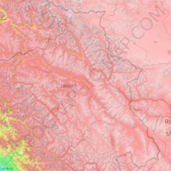
Name: Topografische Karte Ladakh, Höhe, Relief.
Ort: Ladakh, India (32.33574 75.32697 35.67455 79.46075)
Durchschnittliche Höhe: 4.726 m
Minimale Höhe: 337 m
Maximale Höhe: 7.470 m
The Kargil War of 1999, codenamed "Operation Vijay" by the Indian Army, saw infiltration by Pakistani troops into parts of Western Ladakh, namely Kargil, Dras, Mushkoh, Batalik and Chorbatla, overlooking key locations on the Srinagar-Leh highway. Extensive operations were launched in high altitudes by the Indian Army with considerable artillery and air force support. Pakistani troops were evicted from the Indian side of the Line of Control which the Indian government ordered was to be respected and which was not crossed by Indian troops. The Indian government was criticised by the Indian public because India respected geographical co-ordinates more than India's opponents: Pakistan and China.
Andere topografische Karten
Klicken Sie auf eine Karte, um ihre Topografie, ihre Höhe und ihr Relief anzuzeigen.
Chennai
India > Tamil Nadu > Chennai
Chennai, Chennai District, Tamil Nadu, India
Durchschnittliche Höhe: 8 m
Bengaluru
India > Karnataka > Bangalore North
Bengaluru, Bangalore North, Bengaluru Urban District, Karnataka, India
Durchschnittliche Höhe: 881 m
Tharangambadi
Tharangambadi, Mayiladuthurai District, Tamil Nadu, India
Durchschnittliche Höhe: 5 m
Lucknow
India > Uttar Pradesh > Lucknow
Lucknow, Lucknow District, Uttar Pradesh, 226027, India
Durchschnittliche Höhe: 120 m
3d
India > Rajasthan > Ganganagar Tehsil > 1 LNP
3d, 1 LNP, Ganganagar Tehsil, Sri Ganganagar District, Rajasthan, India
Durchschnittliche Höhe: 178 m
Pallapalayam - Kannampalayam Canal
India > Tamil Nadu > Sulur > Kannampalayam
Pallapalayam - Kannampalayam Canal, Papampatti Pirivu, Kannampalayam, Sulur, Coimbatore District, Tamil Nadu, 641402, India
Durchschnittliche Höhe: 381 m
Kolhapur district
Kolhapur district, Maharashtra, India
Durchschnittliche Höhe: 464 m
Coimbatore
India > Tamil Nadu > Coimbatore North
Coimbatore, Coimbatore North, Coimbatore District, Tamil Nadu, 641001, India
Durchschnittliche Höhe: 452 m
Kolkata
Kolkata, Kolkata District, West Bengal, 700073, India
Durchschnittliche Höhe: 5 m
Kannampalayam
India > Tamil Nadu > Mathavaram
Kannampalayam, Mathavaram, Thiruvallur District, Tamil Nadu, 600066, India
Durchschnittliche Höhe: 7 m
Bachupally mandal
Bachupally mandal, Medchal–Malkajgiri District, Telangana, 500090, India
Durchschnittliche Höhe: 593 m
Kodaikanal
Kodaikanal, Dindigul District, Tamil Nadu, India
Durchschnittliche Höhe: 869 m
Prayagraj
India > Uttar Pradesh > Prayagraj
Prayagraj, Prayagraj District, Uttar Pradesh, 211001, India
Durchschnittliche Höhe: 91 m
North Sentinel Island
India > Andaman and Nicobar Islands > Ferrargunj
North Sentinel Island, Ferrargunj, South Andaman District, Andaman and Nicobar Islands, India
Durchschnittliche Höhe: 20 m
Gurgaon
India > Haryana > Gurugram District
Gurgaon, Gurugram District, Haryana, India
Durchschnittliche Höhe: 237 m
Mysuru
India > Karnataka > Mysuru taluk
Mysuru, Mysuru taluk, Mysuru District, Karnataka, 570001, India
Durchschnittliche Höhe: 727 m
Kottakombur
Kottakombur, Devikulam, Idukki District, Kerala, India
Durchschnittliche Höhe: 1.919 m
Thiruvananthapuram
India > Kerala > Thiruvananthapuram
Thiruvananthapuram, Thiruvananthapuram District, Kerala, 695001, India
Durchschnittliche Höhe: 33 m
Pune
India > Maharashtra > Pune City > Pune
Pune, Pune City, Pune District, Maharashtra, 411001, India
Durchschnittliche Höhe: 641 m
Akpa
India > Himachal Pradesh > Moorang
Akpa, Moorang, Kinnaur District, Himachal Pradesh, 172116, India
Durchschnittliche Höhe: 2.709 m
Western Ghats
Western Ghats, Idukki, Kerala, 685614, India
Durchschnittliche Höhe: 2.225 m
Mat
India > Uttar Pradesh > Mathura District
Mat, Mathura District, Uttar Pradesh, India
Durchschnittliche Höhe: 182 m
Maduranthakam
Maduranthakam, Chengalpattu District, Tamil Nadu, India
Durchschnittliche Höhe: 37 m
Srinagar
India > Jammu and Kashmir > Srinagar (South)
Srinagar, Srinagar (South), Srinagar District, Jammu and Kashmir, 190001, India
Durchschnittliche Höhe: 1.805 m