Geolokalisieren

Topografische Karte Saint-Georges

Interaktive Karte

Klicken Sie auf die Karte, um die Höhe anzuzeigen.

Über diese Karte

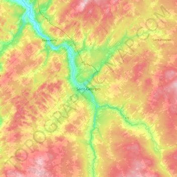
Name: Topografische Karte Saint-Georges, Höhe, Relief.

Ort: Saint-Georges, Beauce-Sartigan, Chaudière-Appalaches, Québec, G5Y 3E5, Canada (45.96299 -70.83196 46.28299 -70.51196)

Durchschnittliche Höhe: 308 m

Minimale Höhe: 140 m

Maximale Höhe: 472 m

Andere topografische Karten

Klicken Sie auf eine Karte, um ihre Topografie, ihre Höhe und ihr Relief anzuzeigen.

Saint-Martin

Canada > Québec > Beauce-Sartigan

Durchschnittliche Höhe: 341 m

Saint-Philibert

Canada > Québec > Beauce-Sartigan

Durchschnittliche Höhe: 334 m

Saint-Simon-les-Mines

Canada > Québec > Beauce-Sartigan

Durchschnittliche Höhe: 285 m

Saint-Théophile

Canada > Québec > Beauce-Sartigan

Durchschnittliche Höhe: 413 m

Lac Wilson

Canada > Québec > Beauce-Sartigan > Saint-Théophile

Durchschnittliche Höhe: 510 m

Beauce

Canada > Québec > Beauce-Sartigan

Durchschnittliche Höhe: 377 m

Saint-Honoré-de-Shenley

Canada > Québec > Beauce-Sartigan

Durchschnittliche Höhe: 377 m

Saint-Éphrem-de-Beauce

Canada > Québec > Beauce-Sartigan

Durchschnittliche Höhe: 315 m

Notre-Dame-des-Pins

Canada > Québec > Beauce-Sartigan

Durchschnittliche Höhe: 242 m

Saint-Gédéon-de-Beauce

Canada > Québec > Beauce-Sartigan

Durchschnittliche Höhe: 374 m

Saint-René

Canada > Québec > Beauce-Sartigan

Durchschnittliche Höhe: 320 m

Saint-Benoît-Labre

Canada > Québec > Beauce-Sartigan

Durchschnittliche Höhe: 317 m

La Guadeloupe

Canada > Québec > Beauce-Sartigan

Durchschnittliche Höhe: 329 m

Saint-Côme–Linière

Canada > Québec > Beauce-Sartigan

Durchschnittliche Höhe: 334 m

Lac des Cygnes

Canada > Québec > Beauce-Sartigan > Saint-Théophile

Durchschnittliche Höhe: 529 m

Saint-Georges

Canada > Québec > Beauce-Sartigan

Durchschnittliche Höhe: 296 m

Lac à France

Canada > Québec > Beauce-Sartigan > Saint-Côme–Linière

Durchschnittliche Höhe: 389 m