
Topografische Karte Taxco
Interaktive Karte
Klicken Sie auf die Karte, um die Höhe anzuzeigen.
Über diese Karte
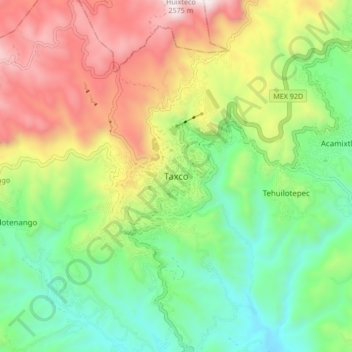
Name: Topografische Karte Taxco, Höhe, Relief.
Ort: Taxco, Taxco de Alarcón, Guerrero, 40200, México (18.51654 -99.64528 18.59654 -99.56528)
Durchschnittliche Höhe: 1.792 m
Minimale Höhe: 1.297 m
Maximale Höhe: 2.551 m
Taxco se encuentra en la región norte de Guerrero, a una altitud promedio de 1,778 metros sobre el nivel del mar.
Andere topografische Karten
Klicken Sie auf eine Karte, um ihre Topografie, ihre Höhe und ihr Relief anzuzeigen.
Acamixtla
México > Guerrero > Taxco de Alarcón
Acamixtla, Taxco de Alarcón, Guerrero, 40211, México
Durchschnittliche Höhe: 1.647 m
Taxco el Viejo
México > Guerrero > Taxco de Alarcón
Taxco el Viejo, Taxco de Alarcón, Guerrero, México
Durchschnittliche Höhe: 1.362 m
Mil Cascadas (Las Granadas)
México > Guerrero > Taxco de Alarcón > Zacapalco
Mil Cascadas (Las Granadas), Rancho Viejo - Taxco, Zacapalco, Taxco de Alarcón, Guerrero, 40000, México
Durchschnittliche Höhe: 1.522 m
Coamazac
México > Guerrero > Taxco de Alarcón > Coamazac
Coamazac, Taxco de Alarcón, Guerrero, México
Durchschnittliche Höhe: 1.124 m
Acuitlapán
México > Guerrero > Taxco de Alarcón > Acuitlapán
Acuitlapán, Taxco de Alarcón, Guerrero, México
Durchschnittliche Höhe: 1.593 m
Teacalco
México > Guerrero > Taxco de Alarcón
Teacalco, Taxco de Alarcón, Guerrero, 62640, México
Durchschnittliche Höhe: 1.063 m