
Topografische Karte Südafrika
Interaktive Karte
Klicken Sie auf die Karte, um die Höhe anzuzeigen.
Über diese Karte
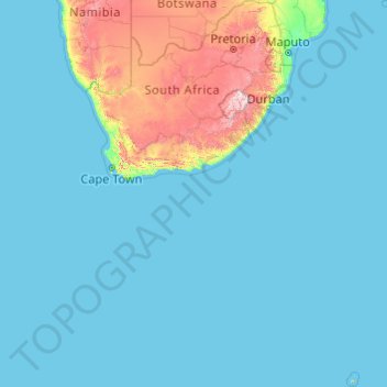
Name: Topografische Karte Südafrika, Höhe, Relief.
Ort: Südafrika (-47.17883 16.33352 -22.12503 38.28990)
Durchschnittliche Höhe: 221 m
Minimale Höhe: 0 m
Maximale Höhe: 3.367 m
Das Land liegt am südlichsten Rand des afrikanischen Kontinents zwischen 22 und 35 Grad südlicher Breite sowie zwischen 17 und 33 Grad östlicher Länge (ohne Berücksichtigung der Prinz-Edward-Inseln). Es hat eine Küstenlinie, die sich über mehr als 2.500 km ausdehnt und an zwei Ozeanen liegt (der Atlantische und der Indische Ozean). Südafrika hat eine Fläche von 1.219.912 km²; das entspricht ungefähr dem 3,4-fachen der Fläche Deutschlands. Das Zentralplateau, auch Highveld genannt, liegt auf einer Höhe zwischen 900 und 2000 m über dem Meeresspiegel. Der zur Küste abfallende Landgürtel mit einer Breite von 20 bis 250 km wird Great Escarpment (Groot Randkant, Große Randstufe) genannt. Weite Teile des Landes sind geomorphologisch und petrografisch von den Sedimenten des Karoo-Hauptbeckens bestimmt. Im Norden treten besonders im Bushveld-Komplex magmatische Gesteine und bei Barberton sehr alte Metamorphite (Grünsteinfazies, Serpentinite) zu Tage.
Andere topografische Karten
Klicken Sie auf eine Karte, um ihre Topografie, ihre Höhe und ihr Relief anzuzeigen.
Masisi
Südafrika > Limpopo > Vhembe District Municipality > Mutale Local Municipality
Masisi, Mutale Local Municipality, Vhembe District Municipality, Limpopo, Südafrika
Durchschnittliche Höhe: 381 m
Bizana
Südafrika > Ostkap > Alfred Nzo District Municipality > Mbizana Local Municipality
Bizana, Mbizana Local Municipality, Alfred Nzo District Municipality, Ostkap, 4800, Südafrika
Durchschnittliche Höhe: 823 m
Douglas
Südafrika > Nordkap > Pixley ka Seme District Municipality > Siyancuma Local Municipality
Douglas, Siyancuma Local Municipality, Pixley ka Seme District Municipality, Nordkap, 8730, Südafrika
Durchschnittliche Höhe: 1.010 m
Thohoyandou
Südafrika > Limpopo > Vhembe District Municipality > Thulamela Local Municipality
Thohoyandou, Thulamela Local Municipality, Vhembe District Municipality, Limpopo, 0950, Südafrika
Durchschnittliche Höhe: 632 m
Heilbron
Südafrika > Freistaat > Ngwathe Local Municipality > Heilbron
Heilbron, Ngwathe Local Municipality, Fezile Dabi District Municipality, Freistaat, Südafrika
Durchschnittliche Höhe: 1.559 m
City of Ekurhuleni Metropolitan Municipality
City of Ekurhuleni Metropolitan Municipality, Gauteng, Südafrika
Durchschnittliche Höhe: 1.588 m
Greater Tubatse Local Municipality
Südafrika > Limpopo > Greater Tubatse Local Municipality
Greater Tubatse Local Municipality, Sekhukhune District Municipality, Limpopo, Südafrika
Durchschnittliche Höhe: 1.140 m
Matjhabeng Local Municipality
Südafrika > Freistaat > Matjhabeng Local Municipality
Matjhabeng Local Municipality, Lejweleputswa District Municipality, Freistaat, Südafrika
Durchschnittliche Höhe: 1.376 m
Johannesburg Ward 97
Südafrika > Gauteng > Roodepoort
Johannesburg Ward 97, Roodepoort, City of Johannesburg Metropolitan Municipality, Gauteng, 2040, Südafrika
Durchschnittliche Höhe: 1.582 m
Vhembe District Municipality
Vhembe District Municipality, Limpopo, Südafrika
Durchschnittliche Höhe: 634 m
Augrabies Falls
Südafrika > Nordkap > Kai !Garib Local Municipality
Augrabies Falls, Kai !Garib Local Municipality, ZF Mgcawu District Municipality, Nordkap, Südafrika
Durchschnittliche Höhe: 618 m
eThekwini Ward 36
Südafrika > KwaZulu-Natal > Durban North
eThekwini Ward 36, Durban North, eThekwini Metropolitan Municipality, KwaZulu-Natal, 4051, Südafrika
Durchschnittliche Höhe: 45 m
Bojanala Platinum District Municipality
Bojanala Platinum District Municipality, Nordwest, Südafrika
Durchschnittliche Höhe: 1.240 m
City of Johannesburg Metropolitan Municipality
City of Johannesburg Metropolitan Municipality, Gauteng, Südafrika
Durchschnittliche Höhe: 1.582 m