
Topografische Karte Pflugerville
Interaktive Karte
Klicken Sie auf die Karte, um die Höhe anzuzeigen.
Über diese Karte
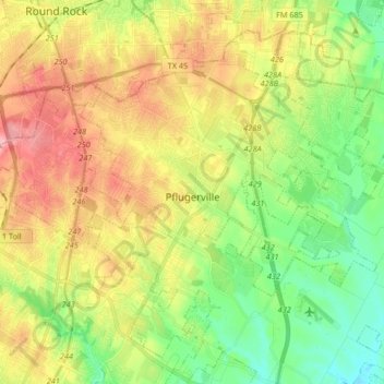
Name: Topografische Karte Pflugerville, Höhe, Relief.
Ort: Pflugerville, Travis County, Texas, United States (30.38142 -97.66882 30.50066 -97.50314)
Durchschnittliche Höhe: 215 m
Minimale Höhe: 158 m
Maximale Höhe: 289 m
Andere topografische Karten
Klicken Sie auf eine Karte, um ihre Topografie, ihre Höhe und ihr Relief anzuzeigen.
McKinney Falls State Park
United States > Texas > Travis County > Austin
Durchschnittliche Höhe: 171 m
East Boggy Creek Greenbelt
United States > Texas > Travis County > Austin
Durchschnittliche Höhe: 144 m
Austin
United States > Texas > Travis County > Austin
The elevation of Austin varies from 425 feet (130 m) to approximately 1,000 feet (305 m) above sea level. Due to the fact it straddles the Balcones Fault, much of the eastern part of the city is flat, with heavy clay and loam soils, whereas the western part and western suburbs consist of rolling hills on the…
Durchschnittliche Höhe: 203 m
Pflugerville
United States > Texas > Travis County > Pflugerville > Pflugerville
Durchschnittliche Höhe: 219 m