
Topografische Karte Statesville
Interaktive Karte
Klicken Sie auf die Karte, um die Höhe anzuzeigen.
Über diese Karte
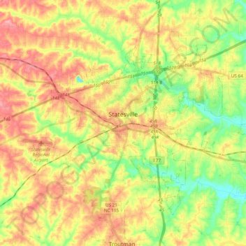
Name: Topografische Karte Statesville, Höhe, Relief.
Durchschnittliche Höhe: 269 m
Minimale Höhe: 220 m
Maximale Höhe: 315 m
Statesville has a humid subtropical climate (Cfa) like most of the state of North Carolina, although its higher elevation leads to cooler temperatures than much of the Piedmont. Summers are generally hot and humid, with mild nights, while winters are usually cool with chilly nights and sporadic snowfall. Severe thunderstorms can be an issue during summer, with wind speeds of 60 mph and even gusts of 95 mph being recorded during these storms.
Andere topografische Karten
Klicken Sie auf eine Karte, um ihre Topografie, ihre Höhe und ihr Relief anzuzeigen.
Mooresville
United States > North Carolina > Iredell County
Mooresville, Iredell County, North Carolina, 28115, United States
Durchschnittliche Höhe: 252 m
Lake Norman
United States > North Carolina > Iredell County > Mooresville
Lake Norman, Mooresville, Iredell County, North Carolina, United States
Durchschnittliche Höhe: 254 m
Shannon Acres
United States > North Carolina > Iredell County > Statesville
Shannon Acres, Statesville, Iredell County, North Carolina, United States
Durchschnittliche Höhe: 254 m
Davidson Creek
United States > North Carolina > Iredell County > Davidson
Davidson Creek, Davidson, Iredell County, North Carolina, 28031, United States
Durchschnittliche Höhe: 236 m
Love Valley
United States > North Carolina > Iredell County
Love Valley, Iredell County, North Carolina, United States
Durchschnittliche Höhe: 374 m
Doolie
United States > North Carolina > Iredell County > Mooresville
Doolie, Mooresville, Iredell County, North Carolina, 28117, United States
Durchschnittliche Höhe: 245 m
Mount Mourne
United States > North Carolina > Iredell County
Mount Mourne, Iredell County, North Carolina, 28123, United States
Durchschnittliche Höhe: 247 m
Barium Springs
United States > North Carolina > Iredell County > Troutman
Barium Springs, Troutman, Iredell County, North Carolina, 28010, United States
Durchschnittliche Höhe: 278 m
Turnersburg
United States > North Carolina > Iredell County
Turnersburg, Iredell County, North Carolina, United States
Durchschnittliche Höhe: 252 m
Harmony
United States > North Carolina > Iredell County
Harmony, Iredell County, North Carolina, 28634, United States
Durchschnittliche Höhe: 286 m
Houstonville
United States > North Carolina > Iredell County
Houstonville, Iredell County, North Carolina, 28634, United States
Durchschnittliche Höhe: 264 m
Scotts
United States > North Carolina > Iredell County
Scotts, Iredell County, North Carolina, 28699, United States
Durchschnittliche Höhe: 303 m
Troutman
United States > North Carolina > Iredell County
Troutman, Iredell County, North Carolina, United States
Durchschnittliche Höhe: 276 m
Olin
United States > North Carolina > Iredell County
Olin, Iredell County, North Carolina, 28660, United States
Durchschnittliche Höhe: 268 m
Bloomfield
United States > North Carolina > Iredell County > Statesville
Bloomfield, Statesville, Iredell County, North Carolina, 28687, United States
Durchschnittliche Höhe: 279 m
Lake Norman State Park
United States > North Carolina > Iredell County > Troutman
Lake Norman State Park, Troutman, Iredell County, North Carolina, 28166, United States
Durchschnittliche Höhe: 247 m
Williamsburg
United States > North Carolina > Iredell County
Williamsburg, Iredell County, North Carolina, 28660, United States
Durchschnittliche Höhe: 293 m
Statesville
United States > North Carolina > Iredell County > Statesville > Statesville
Statesville, Iredell County, North Carolina, 28687, United States
Durchschnittliche Höhe: 266 m
Central
United States > North Carolina > Iredell County > Central
Central, Iredell County, North Carolina, United States
Durchschnittliche Höhe: 305 m
Amity Hill
United States > North Carolina > Iredell County
Amity Hill, Iredell County, North Carolina, 27013, United States
Durchschnittliche Höhe: 257 m