
Topografische Karte Mek'elē
Interaktive Karte
Klicken Sie auf die Karte, um die Höhe anzuzeigen.
Über diese Karte
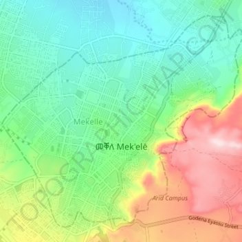
Name: Topografische Karte Mek'elē, Höhe, Relief.
Ort: Mek'elē, Tigray, Ethiopia (13.47492 39.44380 13.53166 39.51051)
Durchschnittliche Höhe: 2.090 m
Minimale Höhe: 1.969 m
Maximale Höhe: 2.330 m
Mekelle (Tigrinya: መቐለ, Amharic: መቀሌ, romanized: mäqälle, mek’elē) or Mekele is a special zone and capital of the Tigray Region of Ethiopia. Mekelle was formerly the capital of Enderta awraja in Tigray. It is located around 780 kilometres (480 mi) north of the Ethiopian capital Addis Ababa, with an elevation of 2,254 metres (7,395 ft) above sea level. Administratively, Mekelle is considered a Special Zone, which is divided into seven sub-cities. It is the economic, cultural, and political hub of northern Ethiopia.
Andere topografische Karten
Klicken Sie auf eine Karte, um ihre Topografie, ihre Höhe und ihr Relief anzuzeigen.
Shire Enda Silassie
Ethiopia > Tigray > Shire Enda Silassie
Shire Enda Silassie, Western Tigray, Tigray, Ethiopia
Durchschnittliche Höhe: 1.912 m