
Topografische Karte Folkstone
Interaktive Karte
Klicken Sie auf die Karte, um die Höhe anzuzeigen.
Über diese Karte
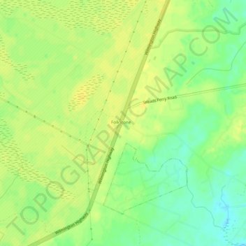
Name: Topografische Karte Folkstone, Höhe, Relief.
Ort: Folkstone, Onslow County, North Carolina, United States (34.51675 -77.52458 34.55675 -77.48458)
Durchschnittliche Höhe: 16 m
Minimale Höhe: 3 m
Maximale Höhe: 23 m
Andere topografische Karten
Klicken Sie auf eine Karte, um ihre Topografie, ihre Höhe und ihr Relief anzuzeigen.
Thomas Landing
United States > North Carolina > Onslow County
Thomas Landing, Onslow County, North Carolina, United States
Durchschnittliche Höhe: 2 m
Sneads Ferry
United States > North Carolina > Onslow County
Sneads Ferry, Onslow County, North Carolina, United States
Durchschnittliche Höhe: 3 m
Humphrey
United States > North Carolina > Onslow County > Jacksonville
Humphrey, Jacksonville, Onslow County, North Carolina, 28546, United States
Durchschnittliche Höhe: 10 m
Marine Corps Base Camp Lejeune
United States > North Carolina > Onslow County > Marine Corps Base Camp Lejeune
Marine Corps Base Camp Lejeune, Onslow County, North Carolina, United States
Durchschnittliche Höhe: 7 m
Bayshore
United States > North Carolina > Onslow County > Jacksonville
Bayshore, Jacksonville, Onslow County, North Carolina, 28540, United States
Durchschnittliche Höhe: 6 m
Onslow Beach
United States > North Carolina > Onslow County > North Topsail Beach
Onslow Beach, North Topsail Beach, Onslow County, North Carolina, United States
Durchschnittliche Höhe: 2 m
Holly Ridge
United States > North Carolina > Onslow County > Holly Ridge
Holly Ridge, Onslow County, North Carolina, 28445, United States
Durchschnittliche Höhe: 13 m
Swansboro
United States > North Carolina > Onslow County > Swansboro
Swansboro, Onslow County, North Carolina, 28584, United States
Durchschnittliche Höhe: 3 m
Jacksonville
United States > North Carolina > Onslow County
Jacksonville, Onslow County, North Carolina, United States
Durchschnittliche Höhe: 10 m