Geolokalisieren

Topografische Karte Giralang

Interaktive Karte

Klicken Sie auf die Karte, um die Höhe anzuzeigen.

Über diese Karte

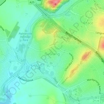
Name: Topografische Karte Giralang, Höhe, Relief.

Ort: Giralang, District of Belconnen, Australian Capital Territory, Australia (-35.21947 149.08437 -35.20143 149.10881)

Durchschnittliche Höhe: 601 m

Minimale Höhe: 575 m

Maximale Höhe: 660 m

Andere topografische Karten

Klicken Sie auf eine Karte, um ihre Topografie, ihre Höhe und ihr Relief anzuzeigen.

Mount Rogers

Australia > District of Belconnen

Mount Rogers is a large hill, with an elevation of 704 metres (2,310 ft), located in the northern suburbs of Canberra, within the Australian Capital Territory, Australia. There is a park called the Mount Rogers Reserve at the crest of the hill, and a trig point at the summit.

Durchschnittliche Höhe: 620 m

Gossan Hill

Australia > District of Belconnen

Durchschnittliche Höhe: 622 m

Ginninderra Creek

Australia > District of Belconnen

Durchschnittliche Höhe: 588 m

Margaret Timpson Park

Australia > District of Belconnen

Durchschnittliche Höhe: 600 m

Diddams Close Park

Australia > District of Belconnen

Durchschnittliche Höhe: 589 m