
Topografische Karte Yanam
Interaktive Karte
Klicken Sie auf die Karte, um die Höhe anzuzeigen.
Über diese Karte
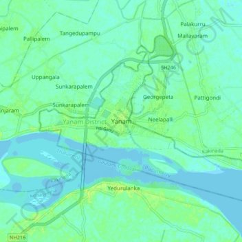
Name: Topografische Karte Yanam, Höhe, Relief.
Ort: Yanam, Yanam Taluk, Yanam District, Puducherry, 533464, India (16.69337 82.17452 16.77337 82.25452)
Durchschnittliche Höhe: 5 m
Minimale Höhe: -3 m
Maximale Höhe: 13 m
In December 1753, a Paravana of Salabat Jang conceded to Bussy the Northern Circars. Salabat Jang was indebted to the French East India Company for his elevation to the throne, which had been confirmed by the Mughal emperor. The agreement made between the French and Salabat Jang in Aurangabad bears the signature of Said Loukshur, Minister of Salabat Jang. Yanam acquired considerable importance during the French occupation of the Northern Circars.