
Topografische Karte Kuala Pilah
Interaktive Karte
Klicken Sie auf die Karte, um die Höhe anzuzeigen.
Über diese Karte
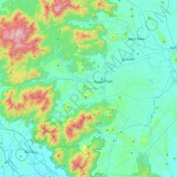
Name: Topografische Karte Kuala Pilah, Höhe, Relief.
Ort: Kuala Pilah, Negeri Sembilan, Malaysia (2.53563 102.04725 2.91108 102.40017)
Durchschnittliche Höhe: 242 m
Minimale Höhe: 18 m
Maximale Höhe: 1.160 m
Andere topografische Karten
Klicken Sie auf eine Karte, um ihre Topografie, ihre Höhe und ihr Relief anzuzeigen.
Broga
The hill, approximately 400 m (1,300 ft) in altitude, is notable for its unique appearance as it is rather devoid of trees, which is an uncommon sight amongst the tropical rainforests surrounding the region. Cogongrass typically dominates the summit area. Remnants of burnt out tree trunks indicate that the…
Durchschnittliche Höhe: 141 m
Gunung Besar Hantu
Due to its higher altitude relative to other Negri mountains, the summit of Besar Hantu experiences a constant cool highland climate, where it also hosts a mossy forest nearby.
Durchschnittliche Höhe: 1.015 m
Gunung Datuk
The main highlight of the mountain is a tor that consists of massive granite boulders, at the elevation of 855 m (2,805 ft).
Durchschnittliche Höhe: 450 m