
Topografische Karte Hayes
Interaktive Karte
Klicken Sie auf die Karte, um die Höhe anzuzeigen.
Über diese Karte
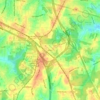
Name: Topografische Karte Hayes, Höhe, Relief.
Durchschnittliche Höhe: 115 m
Minimale Höhe: 91 m
Maximale Höhe: 131 m
Andere topografische Karten
Klicken Sie auf eine Karte, um ihre Topografie, ihre Höhe und ihr Relief anzuzeigen.
Few
United States > North Carolina > Durham County > Durham
Few, Durham, Durham County, North Carolina, 27713, United States
Durchschnittliche Höhe: 102 m
Brassfield
United States > North Carolina > Durham County > Durham
Brassfield, Durham, Durham County, North Carolina, 27703, United States
Durchschnittliche Höhe: 113 m
Durham
United States > North Carolina > Durham County > Durham
Durham, Durham County, North Carolina, 27701, United States
Durchschnittliche Höhe: 119 m
Belmont Lake
United States > North Carolina > Durham County > Durham
Belmont Lake, Crest Street, Durham, Durham County, North Carolina, United States
Durchschnittliche Höhe: 117 m