
Topografische Karte Banner Elk
Interaktive Karte
Klicken Sie auf die Karte, um die Höhe anzuzeigen.
Über diese Karte
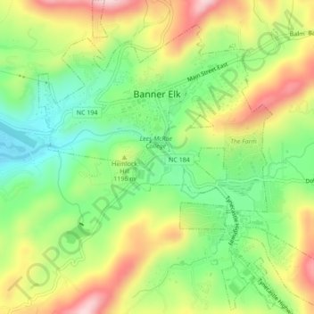
Name: Topografische Karte Banner Elk, Höhe, Relief.
Ort: Banner Elk, Avery County, North Carolina, United States (36.13897 -81.88774 36.17356 -81.84810)
Durchschnittliche Höhe: 1.165 m
Minimale Höhe: 1.036 m
Maximale Höhe: 1.332 m
Banner Elk is located in North America's humid continental climate zone due to its elevation, which gives it a climate more like that of Altoona, Pennsylvania, than Asheville, North Carolina, during the winter. During the summer the temperatures are much like a mountain lake town in New Hampshire. The town typically has cold, snowy winters and mild summers.
Andere topografische Karten
Klicken Sie auf eine Karte, um ihre Topografie, ihre Höhe und ihr Relief anzuzeigen.
Mount Gilead
United States > North Carolina > Avery County
Mount Gilead, Avery County, North Carolina, United States
Durchschnittliche Höhe: 891 m
Beech Mountain
United States > North Carolina > Avery County > Beech Mountain
Beech Mountain, Avery County, North Carolina, 28604, United States
Durchschnittliche Höhe: 1.433 m
Newland
United States > North Carolina > Avery County
Newland, Avery County, North Carolina, United States
Durchschnittliche Höhe: 1.140 m
Sugar Mountain
United States > North Carolina > Avery County > Sugar Mountain
Sugar Mountain, Avery County, North Carolina, United States
Durchschnittliche Höhe: 1.385 m