
Topografische Karte Yellowstone National Park
Interaktive Karte
Klicken Sie auf die Karte, um die Höhe anzuzeigen.
Über diese Karte
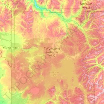
Name: Topografische Karte Yellowstone National Park, Höhe, Relief.
Durchschnittliche Höhe: 2.450 m
Minimale Höhe: 1.560 m
Maximale Höhe: 3.549 m
Yellowstone National Park spans an area of 3,468.4 sq mi (8,983 km2), comprising lakes, canyons, rivers, and mountain ranges. Yellowstone Lake is one of the largest high-elevation lakes in North America and is centered over the Yellowstone Caldera, the largest supervolcano on the continent. The caldera is considered a dormant volcano. It has erupted with tremendous force several times in the last two million years. Well over half of the world's geysers and hydrothermal features are in Yellowstone, fueled by this ongoing volcanism. Lava flows and rocks from volcanic eruptions cover most of the land area of Yellowstone. The park is the centerpiece of the Greater Yellowstone Ecosystem, the largest remaining nearly-intact ecosystem in the Earth's northern temperate zone. In 1978, Yellowstone was named a UNESCO World Heritage Site.
Andere topografische Karten
Klicken Sie auf eine Karte, um ihre Topografie, ihre Höhe und ihr Relief anzuzeigen.
Cody
United States > Wyoming > Park County
Cody, Park County, Wyoming, United States
Durchschnittliche Höhe: 1.557 m