
Topografische Karte Appalachian Mountains
Interaktive Karte
Klicken Sie auf die Karte, um die Höhe anzuzeigen.
Über diese Karte
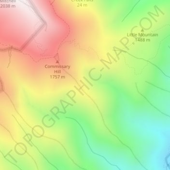
Name: Topografische Karte Appalachian Mountains, Höhe, Relief.
Durchschnittliche Höhe: 1.463 m
Minimale Höhe: 962 m
Maximale Höhe: 2.002 m
The Appalachian Mountains (French: Appalaches), often called the Appalachians, are a system of mountains in eastern to northeastern North America. The Appalachians first formed roughly 480 million years ago during the Ordovician Period. They once reached elevations similar to those of the Alps and the Rocky Mountains before experiencing natural erosion. The Appalachian chain is a barrier to east–west travel, as it forms a series of alternating ridgelines and valleys oriented in opposition to most highways and railroads running east–west.
Andere topografische Karten
Klicken Sie auf eine Karte, um ihre Topografie, ihre Höhe und ihr Relief anzuzeigen.
Burnsville
United States > North Carolina > Yancey County
Burnsville, Yancey County, North Carolina, United States
Durchschnittliche Höhe: 882 m
Mount Mitchell
United States > North Carolina > Yancey County
Mount Mitchell, Yancey County, North Carolina, United States
Durchschnittliche Höhe: 1.743 m
Mitchell Ridge
United States > North Carolina > Yancey County
Mitchell Ridge, Yancey County, North Carolina, United States
Durchschnittliche Höhe: 1.517 m
Cane River
United States > North Carolina > Yancey County > Low Gap
Cane River, Low Gap, Yancey County, North Carolina, 28714, United States
Durchschnittliche Höhe: 944 m
Cane River
United States > North Carolina > Yancey County > Eskota
Cane River, Eskota, Yancey County, North Carolina, United States
Durchschnittliche Höhe: 1.154 m
Lost Cove
United States > North Carolina > Yancey County > Lost Cove
Lost Cove, Yancey County, North Carolina, United States
Durchschnittliche Höhe: 852 m