
Topografische Karte Bucharest
Interaktive Karte
Klicken Sie auf die Karte, um die Höhe anzuzeigen.
Über diese Karte
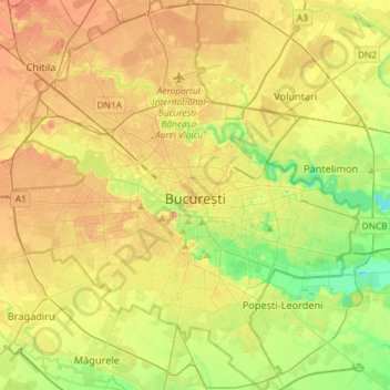
Name: Topografische Karte Bucharest, Höhe, Relief.
Ort: Bucharest, Romania (44.33425 25.96667 44.54140 26.22558)
Durchschnittliche Höhe: 82 m
Minimale Höhe: 49 m
Maximale Höhe: 117 m
The city has an area of 226 km2 (87 sq mi). The altitude varies from 55.8 m (183.1 ft) at the Dâmbovița bridge in Cățelu, southeastern Bucharest and 91.5 m (300.2 ft) at the Militari church. The city has a roughly round shape, with the centre situated in the cross-way of the main north–south/east-west axes at University Square. The milestone for Romania's Kilometre Zero is placed just south of University Square in front of the New St. George Church (Sfântul Gheorghe Nou) at St. George Square (Piața Sfântul Gheorghe). Bucharest's radius, from University Square to the city limits in all directions, varies from 10 to 12 km (6 to 7 mi).
Andere topografische Karten
Klicken Sie auf eine Karte, um ihre Topografie, ihre Höhe und ihr Relief anzuzeigen.
Dorolea
Dorolea, Livezile, Bistrița-Năsăud, 427122, Romania
Durchschnittliche Höhe: 488 m
Vălenii de Munte
Vălenii de Munte, Prahova, 106400, Romania
Durchschnittliche Höhe: 416 m
Dealul cu Drum
Dealul cu Drum, Greci, Tulcea, 827080, Romania
Durchschnittliche Höhe: 168 m