
Topografische Karte Carpathian Mountains
Interaktive Karte
Klicken Sie auf die Karte, um die Höhe anzuzeigen.
Über diese Karte
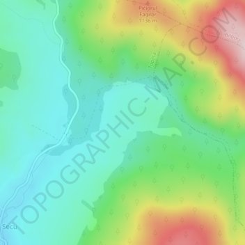
Name: Topografische Karte Carpathian Mountains, Höhe, Relief.
Ort: Carpathian Mountains, Toplița, Harghita, 535705, Romania (47.00052 25.50167 47.00062 25.50177)
Durchschnittliche Höhe: 980 m
Minimale Höhe: 867 m
Maximale Höhe: 1.219 m
The northwestern Carpathians begin in Slovakia and southern Poland. They surround Transcarpathia and Transylvania in a large semicircle, sweeping towards the southeast, and end on the Danube near Orșova in Romania. The total length of the Carpathians is over 1,500 km (930 mi). The mountain chain's width varies between 12 and 500 km (7 and 311 mi). The highest altitudes of the Carpathians occur where they are widest. The system attains its greatest breadth in the Transylvanian plateau and in the southern Tatra Mountains group – the highest range, in which Gerlachovský štít in Slovakia is the highest peak, is 2,655 m (8,711 ft) above sea level. The Carpathians cover an area of 190,000 km2 (73,000 sq mi). After the Alps, they form the next-most extensive mountain system in Europe.