
Topografische Karte Gaya Island
Interaktive Karte
Klicken Sie auf die Karte, um die Höhe anzuzeigen.
Über diese Karte
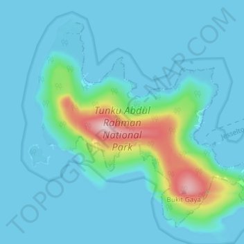
Name: Topografische Karte Gaya Island, Höhe, Relief.
Ort: Gaya Island, Kota Kinabalu, Sabah, Malaysia (5.99168 116.00487 6.04405 116.06626)
Durchschnittliche Höhe: 34 m
Minimale Höhe: -1 m
Maximale Höhe: 255 m
Gaya Island (Malay: Pulau Gaya) is a sizeable Malaysian island of 1,465 ha, just 10 minutes off Kota Kinabalu, Sabah and forms part of the Tunku Abdul Rahman National Park. Gaya Island derived its name from the Bajau word "Gayo" which means big and occupies an area of 15 km² (3,700 acres) with an elevation of up to 300 metres. Several ridges rise more than 600 feet (180 m), peaking at 1,000 feet (300 m), along the backbone of Gaya Island.
Andere topografische Karten
Klicken Sie auf eine Karte, um ihre Topografie, ihre Höhe und ihr Relief anzuzeigen.
Taman Bukit Sepangar
Malaysia > Sabah > Kota Kinabalu
Taman Bukit Sepangar, Kota Kinabalu, West Coast Division, Sabah, Malaysia
Durchschnittliche Höhe: 31 m
Dato Haris Lake
Malaysia > Sabah > Kota Kinabalu
Dato Haris Lake, Luyang Perdana, Kota Kinabalu, Kota Kinabalu District, Sabah, Malaysia
Durchschnittliche Höhe: 10 m
Museum Area
Malaysia > Sabah > Kota Kinabalu
Museum Area, Kota Kinabalu, Kota Kinabalu District, Sabah, Malaysia
Durchschnittliche Höhe: 11 m
KKHS Shanghai Garden
Malaysia > Sabah > Kota Kinabalu
KKHS Shanghai Garden, Taman Tuan Huatt, Kota Kinabalu, Sabah, Malaysia
Durchschnittliche Höhe: 15 m
Sepanggar Island
Malaysia > Sabah > Kota Kinabalu
Sepanggar Island, Kota Kinabalu, Sabah, Malaysia
Durchschnittliche Höhe: 9 m
Tiga Island
Malaysia > Sabah > Kota Kinabalu
Tiga Island, Kota Kinabalu, Sabah, Malaysia
Durchschnittliche Höhe: 10 m
Manukan Island
Malaysia > Sabah > Kota Kinabalu
Manukan Island, Kota Kinabalu, Sabah, Malaysia
Durchschnittliche Höhe: 2 m