
Topografische Karte Mount Kinabalu
Interaktive Karte
Klicken Sie auf die Karte, um die Höhe anzuzeigen.
Mount Kinabalu
Mount Kinabalu (Malay: Gunung Kinabalu, Dusun: Gayo Ngaran or Nulu Nabalu) is the highest mountain in Borneo and Malaysia. With an elevation of 13,435 feet (4,095 m), it is third-highest peak of an island on Earth, and 20th most prominent mountain in the world by topographic prominence. The mountain is located in Ranau district, West Coast Division of Sabah, Malaysia. It is protected as Kinabalu Park, a World Heritage Site.
Über diese Karte
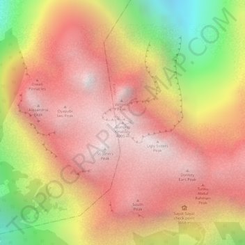
Name: Topografische Karte Mount Kinabalu, Höhe, Relief.
Ort: Mount Kinabalu, Ranau, West Coast Division, Sabah, Malaysia (6.07502 116.55865 6.07512 116.55875)
Durchschnittliche Höhe: 3.567 m
Minimale Höhe: 2.661 m
Maximale Höhe: 4.062 m
Andere topografische Karten
Klicken Sie auf eine Karte, um ihre Topografie, ihre Höhe und ihr Relief anzuzeigen.
Kinabalu Park
Malaysia > Sabah > Ranau > Tinompok
The park headquarters is 88 kilometres away from the city of Kota Kinabalu. There are sealed roads leading towards the park headquarters from other parts of Sabah. It is situated on the southern boundary of Kinabalu Park, at an elevation of 1,563 m (5,128 ft).
Durchschnittliche Höhe: 2.063 m