
Topografische Karte Tryon
Interaktive Karte
Klicken Sie auf die Karte, um die Höhe anzuzeigen.
Über diese Karte
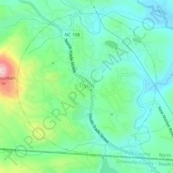
Name: Topografische Karte Tryon, Höhe, Relief.
Ort: Tryon, Polk County, North Carolina, United States (35.19654 -82.25175 35.21942 -82.22512)
Durchschnittliche Höhe: 333 m
Minimale Höhe: 272 m
Maximale Höhe: 498 m
The elevation of the town is 1,067 feet (325 m) above sea level. The town's original boundary was established as a circle with a radius of three quarters of a mile. According to the United States Census Bureau, the town has a total area of 1.8 square miles (4.7 km2), all land.
Andere topografische Karten
Klicken Sie auf eine Karte, um ihre Topografie, ihre Höhe und ihr Relief anzuzeigen.
Peniel
United States > North Carolina > Polk County
Peniel, Polk County, North Carolina, 28722, United States
Durchschnittliche Höhe: 326 m
Saluda
United States > North Carolina > Polk County
Saluda, Polk County, North Carolina, 28773, United States
Durchschnittliche Höhe: 635 m
Howard Gap
United States > North Carolina > Polk County
Howard Gap, Polk County, North Carolina, United States
Durchschnittliche Höhe: 573 m