
Topografische Karte Florida
Interaktive Karte
Klicken Sie auf die Karte, um die Höhe anzuzeigen.
Über diese Karte
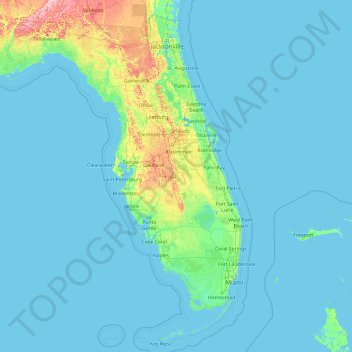
Name: Topografische Karte Florida, Höhe, Relief.
Ort: Florida, United States (24.39631 -87.63490 31.00076 -79.97431)
Durchschnittliche Höhe: 6 m
Minimale Höhe: -3 m
Maximale Höhe: 111 m
Economic prosperity in the 1920s stimulated tourism to Florida and related development of hotels and resort communities. Combined with its sudden elevation in profile was the Florida land boom of the 1920s, which brought a brief period of intense land development. In 1925, the Seaboard Air Line broke the FEC's southeast Florida monopoly and extended its freight and passenger service to West Palm Beach; two years later it extended passenger service to Miami. Devastating hurricanes in 1926 and 1928, followed by the Great Depression, brought that period to a halt. Florida's economy did not fully recover until the military buildup for World War II.
Andere topografische Karten
Klicken Sie auf eine Karte, um ihre Topografie, ihre Höhe und ihr Relief anzuzeigen.
Houston
United States > Texas > Harris County
Houston, Harris County, Texas, United States
Durchschnittliche Höhe: 25 m
Jacksonville
United States > Florida > Duval County
Jacksonville, Duval County, Florida, United States
Durchschnittliche Höhe: 10 m
New Orleans
United States > Louisiana > Orleans Parish
New Orleans, Orleans Parish, Louisiana, United States
Durchschnittliche Höhe: 1 m
Los Angeles
Los Angeles, Los Angeles County, California, United States
Durchschnittliche Höhe: 241 m
Mojave Desert
United States > California > San Bernardino County
Mojave Desert, San Bernardino County, CAL Fire Southern Region, California, United States
Durchschnittliche Höhe: 1.228 m
Badwater Basin
United States > California > Inyo County
Badwater Basin, Inyo County, California, United States
Durchschnittliche Höhe: 152 m
Dubuque
United States > Iowa > Dubuque County
Dubuque, Dubuque County, Iowa, United States
Durchschnittliche Höhe: 241 m
Brookline
United States > Massachusetts > Norfolk County
Brookline, Norfolk County, Massachusetts, United States
Durchschnittliche Höhe: 35 m
Brooklyn
United States > New York > New York
Brooklyn, Kings County, New York, United States
Durchschnittliche Höhe: 9 m
Bentonville
United States > Arkansas > Benton County
Bentonville, Benton County, Arkansas, United States
Durchschnittliche Höhe: 387 m
Guilford County
United States > North Carolina
Guilford County, North Carolina, United States
Durchschnittliche Höhe: 239 m
Folsom
United States > California > Sacramento County
Folsom, Sacramento County, California, United States
Durchschnittliche Höhe: 92 m
Sheboygan County
Sheboygan County, Wisconsin, United States
Durchschnittliche Höhe: 240 m
Allegheny County
Allegheny County, Pennsylvania, United States
Durchschnittliche Höhe: 325 m
Lafayette
United States > Louisiana > Lafayette Parish
Lafayette, Lafayette Parish, Louisiana, United States
Durchschnittliche Höhe: 11 m
Kitsap County
Kitsap County, Washington, United States
Durchschnittliche Höhe: 138 m
Jonesboro
United States > Arkansas > Craighead County > Jonesboro
Jonesboro, Craighead County, Arkansas, United States
Durchschnittliche Höhe: 90 m
Genesee County
Genesee County, Michigan, United States
Durchschnittliche Höhe: 246 m
Erie County
Erie County, Pennsylvania, United States
Durchschnittliche Höhe: 248 m
Amelia Island
United States > Florida > Nassau County > Fernandina Beach
Amelia Island, Fernandina Beach, Nassau County, Florida, 32034, United States
Durchschnittliche Höhe: 3 m
Spokane
United States > Washington > Spokane County
Spokane, Spokane County, Washington, United States
Durchschnittliche Höhe: 655 m