
Topografische Karte Temerloh
Interaktive Karte
Klicken Sie auf die Karte, um die Höhe anzuzeigen.
Über diese Karte
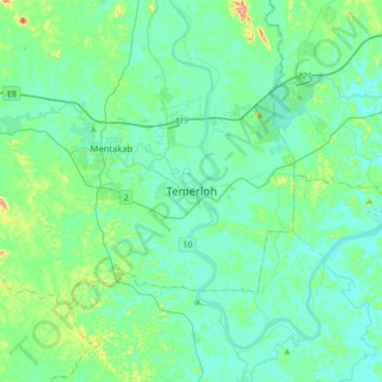
Name: Topografische Karte Temerloh, Höhe, Relief.
Ort: Temerloh, Pahang, 28000, Malaysia (3.29057 102.25910 3.61057 102.57910)
Durchschnittliche Höhe: 48 m
Minimale Höhe: 19 m
Maximale Höhe: 200 m
Andere topografische Karten
Klicken Sie auf eine Karte, um ihre Topografie, ihre Höhe und ihr Relief anzuzeigen.
Padang SMK Jengka Pusat
Malaysia > Pahang > Bandar Tun Abdul Razak (Bandar Jengka)
Durchschnittliche Höhe: 75 m
Sungai Ruan
Covering a total area of 9.7 square km at an average elevation of 227 meters above sea level, the village is surrounded by hills, forest and plantations with a population of about 6,000 people.
Durchschnittliche Höhe: 142 m
Tioman Island
Local mythology claims that the island is the embodiment of the mighty dragon Sri Gumom. The dragon was on his way to visit his sister Gunung Linga (Lingin Peak). Still, the great Sri Rama forbade the meeting, and Sri Gumom was turned into a stone and fell into the deep sea where he now remains, frozen in…
Durchschnittliche Höhe: 104 m
Cameron Highlands
Surveyed by the government geologist and explorer William Cameron in 1885, the outpost consists of three mukims (subdistricts), namely Ringlet, Tanah Rata and Ulu Telom. Its eight settlements are Ringlet, Tanah Rata (the administrative centre), Brinchang, the Bertam Valley, Kea Farm, Tringkap, Kampung Kuala…
Durchschnittliche Höhe: 1.117 m
Malaysia National Park
Taman Negara features a largely virgin, lowland dipterocarp rainforest as well as Peninsular Malaysian montane rain forests on the higher elevation parts of the park.
Durchschnittliche Höhe: 320 m