
Topografische Karte Nuneaton
Interaktive Karte
Klicken Sie auf die Karte, um die Höhe anzuzeigen.
Über diese Karte
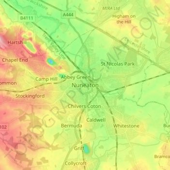
Name: Topografische Karte Nuneaton, Höhe, Relief.
Durchschnittliche Höhe: 101 m
Minimale Höhe: 39 m
Maximale Höhe: 172 m
Andere topografische Karten
Klicken Sie auf eine Karte, um ihre Topografie, ihre Höhe und ihr Relief anzuzeigen.
Nuneaton Common
United Kingdom > England > Warwickshire > Nuneaton and Bedworth
Nuneaton Common, Whittleford, Nuneaton and Bedworth, Warwickshire, England, United Kingdom
Durchschnittliche Höhe: 127 m
Ash Green
United Kingdom > England > Warwickshire > Nuneaton and Bedworth > Ash Green
Ash Green, Nuneaton and Bedworth, Warwickshire, England, CV7 9AQ, United Kingdom
Durchschnittliche Höhe: 111 m
Horeston Grange
United Kingdom > England > Warwickshire > Nuneaton and Bedworth
Horeston Grange, Nuneaton and Bedworth, Warwickshire, England, CV11 6YL, United Kingdom
Durchschnittliche Höhe: 90 m
Exhall
United Kingdom > England > Warwickshire > Nuneaton and Bedworth
Exhall, Nuneaton and Bedworth, Warwickshire, England, CV7 9DJ, United Kingdom
Durchschnittliche Höhe: 101 m
Bedworth
United Kingdom > England > Warwickshire > Nuneaton and Bedworth
Bedworth, Nuneaton and Bedworth, Warwickshire, England, CV12 9DQ, United Kingdom
Durchschnittliche Höhe: 105 m
Bulkington
United Kingdom > England > Warwickshire > Nuneaton and Bedworth
Bulkington, Nuneaton and Bedworth, Warwickshire, England, CV12 9NN, United Kingdom
Durchschnittliche Höhe: 107 m