Geolokalisieren

Topografische Karte Alappuzha

Interaktive Karte

Klicken Sie auf die Karte, um die Höhe anzuzeigen.

Alappuzha

The Vembanad lake, which lies below the sea level, is the longest lake in the Indian peninsula, and the district of Alappuzha lies between this lake and the Arabian Sea. Kuttanad region of the Alappuzha district, which lies below the sea level, is the point of least elevation in the entire India. Kuttanad, also known as The Rice Bowl of Kerala, has the lowest altitude in India, and is also one of the few places in the world where cultivation takes place below the sea level.

Wikipedia (CC-BY-SA 3.0)

Über diese Karte

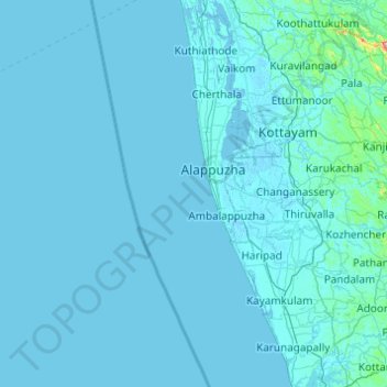
Name: Topografische Karte Alappuzha, Höhe, Relief.

Ort: Alappuzha, Kerala, India (9.11014 76.27946 9.89101 76.69113)

Durchschnittliche Höhe: 21 m

Minimale Höhe: -5 m

Maximale Höhe: 937 m

Andere topografische Karten

Klicken Sie auf eine Karte, um ihre Topografie, ihre Höhe und ihr Relief anzuzeigen.

Thiruvananthapuram

India > Kerala > Thiruvananthapuram

Thiruvananthapuram is built on seven hills by the seashore and is at 8°30′N 76°54′E / 8.5°N 76.9°E / 8.5; 76.9 on the west coast, near the southern tip of mainland India. The city is on the west coast of India and is bounded by the Laccadive Sea to its west and the Western Ghats to its east.…

Durchschnittliche Höhe: 33 m

Kochi

India > Kerala > Kochi

Durchschnittliche Höhe: 4 m

Pallam

India > Kerala > Kottayam

Durchschnittliche Höhe: 9 m

Peermade

India > Kerala > Peerumade

The landscape of Peermade includes spectacular waterfalls, open grass lands and pine forests. Predominantly it is classified as Malanad with an elevation ranging from 3,000 ft (910 m) from the mean sea level.

Durchschnittliche Höhe: 918 m

Manacaud Park

India > Kerala > Thiruvananthapuram > Thiruvananthapuram

Durchschnittliche Höhe: 15 m

Payaswini

India > Kerala > Hosdurg > Kakkat > Keekkamkote

Durchschnittliche Höhe: 42 m

Western Ghats

India > Kerala > Devikulam

The range starts near south of the Tapti river and runs approximately 1,600 km (990 mi) through the states of Gujarat, Maharashtra, Karnataka, Goa, Kerala and Tamil Nadu ending at Marunthuvazh Malai, Swamithope near the southern tip of India. These hills cover 160,000 km2 (62,000 sq mi) and form the catchment…

Durchschnittliche Höhe: 2.225 m

Kainoor

India > Kerala > Thrissur

Durchschnittliche Höhe: 22 m

Kozhikode

India > Kerala > Kozhikode

Durchschnittliche Höhe: 14 m

Kattappana

India > Kerala > Idukki

The average elevation of Kattappana Municipality is 950 m above sea level.

Durchschnittliche Höhe: 950 m

Vaduvanchal

India > Kerala

Durchschnittliche Höhe: 858 m

Malampuzha

India > Kerala > Palakkad

Durchschnittliche Höhe: 101 m

Nilamel

India > Kerala > Kottarakkara

Durchschnittliche Höhe: 89 m

Mutholy

India > Kerala > Meenachil

Durchschnittliche Höhe: 28 m

Thiruvananthapuram

India > Kerala > Thiruvananthapuram

Thiruvananthapuram is built on seven hills by the seashore and is at 8°30′N 76°54′E / 8.5°N 76.9°E / 8.5; 76.9 on the west coast, near the southern tip of mainland India. The city is on the west coast of India and is bounded by the Laccadive Sea to its west and the Western Ghats to its east.…

Durchschnittliche Höhe: 33 m

Kozhikode

India > Kerala > Kozhikode

Durchschnittliche Höhe: 14 m

Puzhathi

India > Kerala > Kannur

Durchschnittliche Höhe: 19 m

Muthanga

India > Kerala > Sulthanbathery

Durchschnittliche Höhe: 866 m

Konnappara

India > Kerala > Konni

Durchschnittliche Höhe: 107 m

Alathur

India > Kerala > Alathur

Durchschnittliche Höhe: 66 m

Thrissur

India > Kerala > Thrissur

Thrissur is the headquarters of Thrissur district, in the center of the Indian state of Kerala. The city is 75 km north-east of Kochi, 133 km south-west of Coimbatore, 124 km south-east of Kozhikode and 151 km north of Changanacherry. The city is located in a hillock called Thekkinkadu Maidan which is the…

Durchschnittliche Höhe: 36 m

Kollam

India > Kerala > Kollam

Cosmas Indicopleustes, a Greek Nestorian sailor, in his book the Christian Topography who visited the Malabar Coast in 550, mentions an enclave of Christian believers in Male (Malabar Coast). He writes, "In the island of Tabropane (Ceylon), there is a church of Christians, and clerics and faithful. Likewise at…

Durchschnittliche Höhe: 11 m

Thekkady

India > Kerala > Peerumade

Durchschnittliche Höhe: 932 m

Kakkayangad

India > Kerala > Iritty

Durchschnittliche Höhe: 94 m

Purameri

India > Kerala > Vadakara

Durchschnittliche Höhe: 19 m

Piravanthur

India > Kerala > Pathanapuram

Durchschnittliche Höhe: 63 m

Areekode

India > Kerala > Ernad

Durchschnittliche Höhe: 43 m

Vellora

India > Kerala > Payyannur Taluk

Durchschnittliche Höhe: 99 m

Kaikatty

India > Kerala > Chittur

Durchschnittliche Höhe: 929 m

Kappilikunnu

India > Kerala > Meenachil

Durchschnittliche Höhe: 76 m

Panchalimedu

India > Kerala > Peerumade

Durchschnittliche Höhe: 575 m

Kakkad

India > Kerala > Koyilandi > Kaithaikal

Durchschnittliche Höhe: 34 m

Paimbalassery

India > Kerala > Kozhikode

Durchschnittliche Höhe: 39 m

Nedumkunnam

India > Kerala > Changanassery

Durchschnittliche Höhe: 67 m

Neeloor

India > Kerala > Meenachil

Durchschnittliche Höhe: 190 m

Thiruvananthapuram

India > Kerala > Thiruvananthapuram

Thiruvananthapuram is built on seven hills by the seashore and is at 8°30′N 76°54′E / 8.5°N 76.9°E / 8.5; 76.9 on the west coast, near the southern tip of mainland India. The city is on the west coast of India and is bounded by the Laccadive Sea to its west and the Western Ghats to its east.…

Durchschnittliche Höhe: 33 m

Kumbanad

India > Kerala > Thiruvalla

Durchschnittliche Höhe: 24 m

Palliyol pothu Kulam

India > Kerala > Kozhikode > Mavoor

Durchschnittliche Höhe: 26 m

Vellaramkunnu

India > Kerala > Peerumade

Durchschnittliche Höhe: 1.030 m

Pavukkonam

India > Kerala > Ottappalam

Durchschnittliche Höhe: 75 m

Pozhiyoor

India > Kerala > Neyyattinkara

Durchschnittliche Höhe: 15 m

Kallikkad

India > Kerala > Kattakkada

Durchschnittliche Höhe: 86 m

Willingdon Island

India > Kerala > Kochi > Kochi

Durchschnittliche Höhe: 4 m

Karikkad

India > Kerala > Kunnamkulam

Durchschnittliche Höhe: 14 m

Mukkam

India > Kerala > Kozhikode

Durchschnittliche Höhe: 50 m

Thenmala

India > Kerala > Punalur

Durchschnittliche Höhe: 212 m

East Mattukkatta

India > Kerala > Idukki > Vellilamkandam

Durchschnittliche Höhe: 831 m

Tirur

India > Kerala > Tirur

Tirur is a major trading centre for electronic devices and seafood in Northern Kerala and has an average elevation of 2 metres (6 ft 7 in) above the sea level.

Durchschnittliche Höhe: 15 m

Kollengode

India > Kerala > Chittur

Durchschnittliche Höhe: 103 m

Western Ghats

India > Kerala > Devikulam

Geologic evidence indicates that the mountains were formed during the break-up of the supercontinent of Gondwana. The mountains came along the west coast of India somewhere in the late Jurassic and early Cretaceous periods when India separated from the African continent. The mountains can be roughly divided…

Durchschnittliche Höhe: 2.225 m

Vellarimala

India > Kerala > Thamarassery > Vythiri

Durchschnittliche Höhe: 1.773 m

Kundayithode

India > Kerala > Kozhikode

Durchschnittliche Höhe: 13 m

Thrissur

India > Kerala > Thrissur

Thrissur is the headquarters of Thrissur district, in the center of the Indian state of Kerala. The city is 75 km north-east of Kochi, 133 km south-west of Coimbatore, 124 km south-east of Kozhikode and 151 km north of Changanacherry. The city is located in a hillock called Thekkinkadu Maidan which is the…

Durchschnittliche Höhe: 36 m

Elangoi

India > Kerala > Changanassery

Durchschnittliche Höhe: 57 m

Pallam

India > Kerala > Kottayam

Durchschnittliche Höhe: 9 m

Maniyur

India > Kerala > Vadakara

Durchschnittliche Höhe: 19 m

Koothattukulam

India > Kerala > Muvattupuzha

Durchschnittliche Höhe: 61 m

Anamalai

India > Kerala > Devikulam

Durchschnittliche Höhe: 2.023 m

Malankara Dam

India > Kerala > Thodupuzha > Muttam

Durchschnittliche Höhe: 59 m

Vallakkadavu

India > Kerala > Peerumade

Durchschnittliche Höhe: 922 m

Thengamam

India > Kerala > Adoor

Durchschnittliche Höhe: 28 m

Kadachira

India > Kerala > Kannur

Durchschnittliche Höhe: 19 m

Cherai

India > Kerala > Kochi

Durchschnittliche Höhe: 3 m

Devikulam

India > Kerala > Devikulam

Durchschnittliche Höhe: 1.619 m

Thachottukavu

India > Kerala > Kattakkada

Durchschnittliche Höhe: 43 m

Adivad

India > Kerala > Kothamangalam

Durchschnittliche Höhe: 37 m

Karipur

India > Kerala > Kondotty

Durchschnittliche Höhe: 57 m

Kanjirakolly

India > Kerala > Taliparamba

Durchschnittliche Höhe: 421 m

Tanur

India > Kerala > Tirur

Tanur is located at 10°58′N 75°52′E / 10.97°N 75.87°E / 10.97; 75.87. It has an average elevation of 1 m (3.3 ft).

Durchschnittliche Höhe: 8 m

Edamalakkudy

India > Kerala > Kothamangalam

Edamalakudy is located at an elevation of 1100–1700 metres, 22 km north-west of Pettimudi, a village about 4 km west of the Anamudi, the tallest mountain peak in South India on the border of Ernakulam district and Idukki district. Pettimudi was hit by a landslide in 2018 and the debris have not been cleared.…

Durchschnittliche Höhe: 1.095 m

Perumkadavila

India > Kerala > Neyyattinkara

Durchschnittliche Höhe: 55 m

Idukki

India > Kerala > Idukki

Durchschnittliche Höhe: 697 m

Kadapra

India > Kerala > Thiruvalla

Durchschnittliche Höhe: 5 m

Paththaam Kallu

India > Kerala > Nedumangad

Durchschnittliche Höhe: 71 m

Chembra peak

India > Kerala > Thamarassery > Vythiri

Durchschnittliche Höhe: 1.628 m

Paplassery

India > Kerala > Sulthanbathery

Durchschnittliche Höhe: 795 m

Valayam

India > Kerala > Vadakara

Durchschnittliche Höhe: 32 m

Meenachil

India > Kerala > Kottayam > Pulikuttisseri

Durchschnittliche Höhe: 7 m

Kollam

India > Kerala > Kollam

Cosmas Indicopleustes, a Greek Nestorian sailor, in his book the Christian Topography who visited the Malabar Coast in 550, mentions an enclave of Christian believers in Male (Malabar Coast). He writes, "In the island of Tabropane (Ceylon), there is a church of Christians, and clerics and faithful. Likewise at…

Durchschnittliche Höhe: 11 m

Erattupetta

India > Kerala > Meenachil

Erattupetta can be easily accessed from north Kerala via the Angamaly-Muvattupuzha-Thodupuzha-Muttom route. It is also well connected to Tamil Nadu via the Kottayam-Kumali Road(KK Road) to Madurai, through the nearest town, Mundakkayam, via Parathanam, which is 27 kilometers from Erattupetta. The town has an…

Durchschnittliche Höhe: 78 m

Kannankode

India > Kerala > Kottarakkara

Durchschnittliche Höhe: 77 m

Valakom

India > Kerala > Muvattupuzha

Durchschnittliche Höhe: 23 m

Thiruvananthapuram

India > Kerala > Thiruvananthapuram

Thiruvananthapuram is built on seven hills by the seashore and is at 8°30′N 76°54′E / 8.5°N 76.9°E / 8.5; 76.9 on the west coast, near the southern tip of mainland India. The city is on the west coast of India and is bounded by the Laccadive Sea to its west and the Western Ghats to its east.…

Durchschnittliche Höhe: 33 m

Oachira

India > Kerala > Karunagappally

Durchschnittliche Höhe: 10 m

Pathanapuram

India > Kerala > Pathanapuram

Durchschnittliche Höhe: 57 m

Pampady

India > Kerala > Kottayam

Durchschnittliche Höhe: 55 m

Vazhakulam

India > Kerala > Muvattupuzha

Durchschnittliche Höhe: 41 m

Adimali

India > Kerala > Devikulam

Adimaly generally has a cool climate throughout the year, typical of the higher altitudes, though not as cold as Munnar. Temperatures rarely exceed 26 degrees and never drop below 10 degrees as it usually stays around 17-24 degrees. December and January are cooler than other months. Adimaly is a place with…

Durchschnittliche Höhe: 786 m

Devikulam

India > Kerala > Devikulam

Durchschnittliche Höhe: 1.619 m

Malappuram

India > Kerala > Ernad

Durchschnittliche Höhe: 56 m

Chaliyangod

India > Kerala > Kasaragod

Durchschnittliche Höhe: 23 m

Chembra

India > Kerala > Pattambi

Durchschnittliche Höhe: 23 m

Eachome

India > Kerala > Mananthavady

Durchschnittliche Höhe: 749 m

Munnar

India > Kerala > Devikulam

Durchschnittliche Höhe: 1.603 m

Anchal

India > Kerala > Punalur

Durchschnittliche Höhe: 79 m

Chadayamangalam

India > Kerala > Kottarakkara

Durchschnittliche Höhe: 70 m

Kattappana

India > Kerala > Idukki

The average elevation of Kattappana Municipality is 950 m above sea level.

Durchschnittliche Höhe: 950 m

Palolipalam

India > Kerala > Vadakara

Durchschnittliche Höhe: 12 m