
Topografische Karte Vellore
Interaktive Karte
Klicken Sie auf die Karte, um die Höhe anzuzeigen.
Über diese Karte
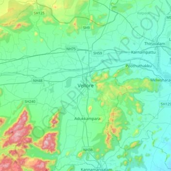
Name: Topografische Karte Vellore, Höhe, Relief.
Ort: Vellore, Vellore District, Tamil Nadu, 632012, India (12.74718 78.97097 13.06718 79.29097)
Durchschnittliche Höhe: 283 m
Minimale Höhe: 153 m
Maximale Höhe: 882 m
Vellore is at 12°55′N 79°08′E / 12.92°N 79.13°E / 12.92; 79.13, 220m above sea level. The city has a tropical savanna climate. It is in the Vellore district of the South Indian state, Tamil Nadu, 135 km (84 mi) west of the state capital Chennai and 30 km (19 mi) kms South of its twin city Chittoor, across the Andhra Pradesh border.Vellore lies in the Eastern Ghats region and Palar river basin. The topography is almost flat with slope from west to east.
Andere topografische Karten
Klicken Sie auf eine Karte, um ihre Topografie, ihre Höhe und ihr Relief anzuzeigen.
Vallam
India > Tamil Nadu > Vellore
Vallam, Vellore, Vellore District, Tamil Nadu, 632319, India
Durchschnittliche Höhe: 203 m