
Topografische Karte Udhampur
Interaktive Karte
Klicken Sie auf die Karte, um die Höhe anzuzeigen.
Über diese Karte
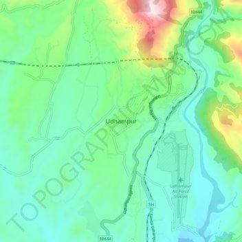
Name: Topografische Karte Udhampur, Höhe, Relief.
Ort: Udhampur, Jammu and Kashmir, 182101, India (32.88197 75.09315 32.96197 75.17315)
Durchschnittliche Höhe: 725 m
Minimale Höhe: 544 m
Maximale Höhe: 1.322 m
The district of Udhampur is located in the Shivalik range of Himalayas and the terrain is mostly mountainous. The upper reaches of the district experience snowfall in the winter season. The city itself is in a relatively flatter part of the district at an elevation of 756 metres (2480 feet) and it rarely experiences any snowfall.