

Topografische Karte Malang
Klicken Sie auf die Karte, um die Höhe anzuzeigen.
Malang
The city was capital city of Singhasari in 1222, then transferred to Dutch colony. Malang was modernized under the Dutch; its mild climate which results from its elevation, along with its proximity to the major port of Surabaya, made it a popular destination for the Dutch and other Europeans. Malang began to grow and develop rapidly and various economic sectors of the community were increasing, especially the need for space to carry out various activities. As a result, there was a change in land use which was marked by a built up area that appeared uncontrollably. Changes in land functions undergo rapid changes, such as from functioning land agriculture becomes a functioning land of housing and industry. In 1879, Malang was connected to Java's railroad network, further increasing development and leading to increased industrialization. On 1 April 1914, Malang was designated gemeente (city).
Über diese Karte
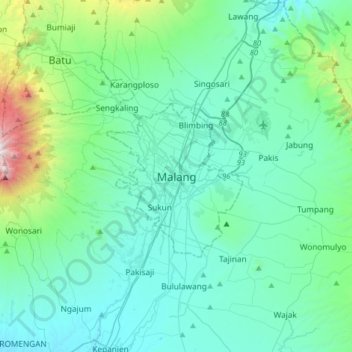
Name: Topografische Karte Malang, Höhe, Relief.
Ort: Malang, Kota Malang, East Java, 65119, Indonesia (-8.13712 112.47403 -7.81712 112.79403)
Durchschnittliche Höhe: 657 m
Minimale Höhe: 296 m
Maximale Höhe: 2.740 m
Andere topografische Karten
Klicken Sie auf eine Karte, um ihre Topografie, ihre Höhe und ihr Relief anzuzeigen.

RW 11 Kelurahan Merjosari Kecamatan Lowokwaru Kota Malang
Indonesia > East Java > Kota Malang > Malang
Durchschnittliche Höhe: 597 m
RW 06 Kel. Kotalama Kec. Kedung Kandang, Kota Malang
Indonesia > East Java > Kota Malang > Malang > Kotalama
Durchschnittliche Höhe: 434 m