
Topografische Karte Burleson
Interaktive Karte
Klicken Sie auf die Karte, um die Höhe anzuzeigen.
Über diese Karte
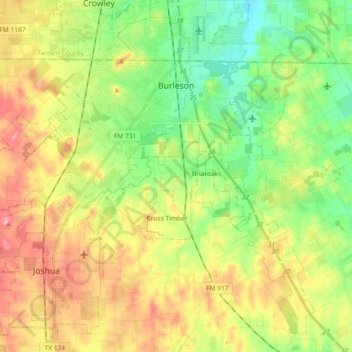
Name: Topografische Karte Burleson, Höhe, Relief.
Ort: Burleson, Johnson County, Texas, United States (32.43272 -97.43155 32.57192 -97.24890)
Durchschnittliche Höhe: 244 m
Minimale Höhe: 193 m
Maximale Höhe: 312 m
As of 2010, Burleson had a total area of 26.07 square miles (67.52 km2), of which 26.01 square miles (67.36 km2) were land and 0.07 square miles (0.17 km2), or 0.25%, were water. Village Creek, a tributary of the Trinity River, flows to the northeast through the city. Most of Burleson lies between 700 and 800 feet (210 and 240 m) in elevation.
Andere topografische Karten
Klicken Sie auf eine Karte, um ihre Topografie, ihre Höhe und ihr Relief anzuzeigen.
Alvarado
United States > Texas > Johnson County
Alvarado, Johnson County, Texas, 76007, United States
Durchschnittliche Höhe: 224 m
Joshua
United States > Texas > Johnson County
Joshua, Johnson County, Texas, United States
Durchschnittliche Höhe: 269 m
Rio Vista
United States > Texas > Johnson County
Rio Vista, Johnson County, Texas, United States
Durchschnittliche Höhe: 219 m
Egan
United States > Texas > Johnson County
Egan, Johnson County, Texas, United States
Durchschnittliche Höhe: 255 m
Cuba
United States > Texas > Johnson County
Cuba, Johnson County, Texas, United States
Durchschnittliche Höhe: 245 m
Cleburne
United States > Texas > Johnson County
Cleburne, Johnson County, Texas, United States
Durchschnittliche Höhe: 254 m
Grandview
United States > Texas > Johnson County
Grandview, Johnson County, Texas, United States
Durchschnittliche Höhe: 206 m
Venus
United States > Texas > Johnson County
Venus, Johnson County, Texas, 76084, United States
Durchschnittliche Höhe: 200 m