
Topografische Karte Bidar
Interaktive Karte
Klicken Sie auf die Karte, um die Höhe anzuzeigen.
Über diese Karte
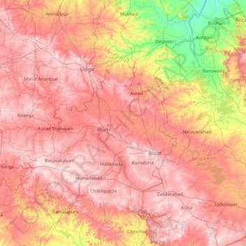
Name: Topografische Karte Bidar, Höhe, Relief.
Ort: Bidar, Bidar District, Karnataka, India (17.38333 76.63333 18.78333 78.03333)
Durchschnittliche Höhe: 536 m
Minimale Höhe: 336 m
Maximale Höhe: 694 m
Andere topografische Karten
Klicken Sie auf eine Karte, um ihre Topografie, ihre Höhe und ihr Relief anzuzeigen.
Bengaluru
India > Karnataka > Bangalore North
Bengaluru (formerly Bangalore) is situated in the southeastern part of Karnataka, India, within the Bengaluru Urban district. It lies at an elevation of approximately 900 meters (3,000 feet) above sea level, on the Deccan Plateau. This elevated position gives the city a moderate climate, with temperatures…
Durchschnittliche Höhe: 886 m
Nandi Hills State Forest
India > Karnataka > Chikkaballapura taluk > Kanivenarayanapura
Durchschnittliche Höhe: 853 m
Bidar
Physiographically, the district can be divided into two regions, the northern low lands and southern high lands. The southern high lands are popularly known as Bidar plateau, which is made up of laterite. The ground altitudes are varying from 420 to 684 m (1,378 to 2,244 ft) above sea level. Bidar plateau has…
Durchschnittliche Höhe: 576 m
Bidar
India > Karnataka > Bidar taluku > Bidar
Bidar is located at 17°54′N 77°30′E / 17.9°N 77.5°E / 17.9; 77.5, lies at a central position in Deccan, a plateau at an elevation of 2300 ft from the sea level. It has common boundaries with Maharashtra and Telangana which is, with the districts of Nizamabad and Medak in Telangana on the East…
Durchschnittliche Höhe: 631 m
Nandi Hills State Forest
India > Karnataka > Chikkaballapura taluk > Kanivenarayanapura
Durchschnittliche Höhe: 853 m
Bengaluru
India > Karnataka > Bangalore North
Bengaluru (formerly Bangalore) is situated in the southeastern part of Karnataka, India, within the Bengaluru Urban district. It lies at an elevation of approximately 900 meters (3,000 feet) above sea level, on the Deccan Plateau. This elevated position gives the city a moderate climate, with temperatures…
Durchschnittliche Höhe: 886 m
Ramanagara
Ramanagara is approximately 50 km southwest of Bangalore. The district shares borders with the districts of Bangalore Urban in the east, Bangalore Rural in the North-east, Tumakuru in the North-west, Mandya in the west and Chamarajanagara in the south-west and Krishnagiri district of Tamilnadu state in the…
Durchschnittliche Höhe: 764 m
Kalaburagi
Kalaburagi is situated in Deccan Plateau located at 17°20′N 76°50′E / 17.33°N 76.83°E / 17.33; 76.83 and the general elevation ranges from 300 to 750 meters above mean sea level. The main river is the Bhima.
Durchschnittliche Höhe: 497 m
Kalaburagi
Kalaburagi is situated in Deccan Plateau located at 17°20′N 76°50′E / 17.33°N 76.83°E / 17.33; 76.83 and the general elevation ranges from 300 to 750 meters above mean sea level. The main river is the Bhima.
Durchschnittliche Höhe: 497 m
Uttara Kannada
The district's high rainfall supports lush forests, which cover approximately 70% of the district. The Malabar Coast moist forests ecoregion lies in a narrow strip between the Arabian Sea and the foothills of the Western Ghats up to 250 meters elevation. These forests have been almost completely converted to…
Durchschnittliche Höhe: 364 m
Bengaluru
India > Karnataka > Bangalore North
Bengaluru (formerly Bangalore) is situated in the southeastern part of Karnataka, India, within the Bengaluru Urban district. It lies at an elevation of approximately 900 meters (3,000 feet) above sea level, on the Deccan Plateau. This elevated position gives the city a moderate climate, with temperatures…
Durchschnittliche Höhe: 886 m