Geolokalisieren

Topografische Karte Muar

Interaktive Karte

Klicken Sie auf die Karte, um die Höhe anzuzeigen.

Über diese Karte

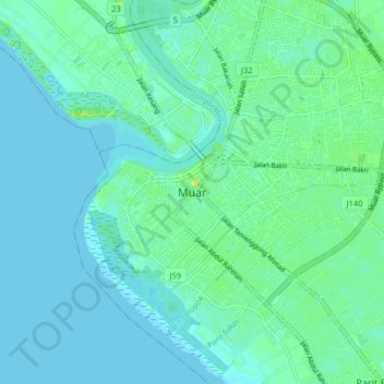
Name: Topografische Karte Muar, Höhe, Relief.

Ort: Muar, Johor, 84000, Malaysia (1.88250 102.40589 2.20250 102.72589)

Durchschnittliche Höhe: 7 m

Minimale Höhe: 0 m

Maximale Höhe: 215 m

Andere topografische Karten

Klicken Sie auf eine Karte, um ihre Topografie, ihre Höhe und ihr Relief anzuzeigen.

Pantai Minyak Beku

Malaysia > Johor > Batu Pahat

Durchschnittliche Höhe: 4 m

Batu Pahat

Malaysia > Johor

Durchschnittliche Höhe: 19 m

Iskandar Puteri

Malaysia > Johor

Durchschnittliche Höhe: 26 m

Kulai

Malaysia > Johor

Durchschnittliche Höhe: 40 m

Kampung Sepakat Baru

Malaysia > Johor > Iskandar Puteri

Durchschnittliche Höhe: 23 m

Forest City

Malaysia > Johor > Iskandar Puteri > Kampung Tanjung Kupang

Durchschnittliche Höhe: 1 m

Batu Pahat

Malaysia > Johor

Durchschnittliche Höhe: 19 m

Hutan Bandar Majlis Perbandaran Kulai

Malaysia > Johor > Kulai

Durchschnittliche Höhe: 45 m

Sungai Sekudai

Malaysia > Johor > Iskandar Puteri

Durchschnittliche Höhe: 14 m

Segamat

Malaysia > Johor

Durchschnittliche Höhe: 81 m

Taman Merdeka

Malaysia > Johor > Kluang

Durchschnittliche Höhe: 44 m

Parit Yusof

Malaysia > Johor > Parit Sulong

Durchschnittliche Höhe: 4 m

Iskandar Puteri

Malaysia > Johor

Durchschnittliche Höhe: 26 m

Mawar Island

Malaysia > Johor

Durchschnittliche Höhe: 1 m

Johor River

Malaysia > Johor > Kota Tinggi

Durchschnittliche Höhe: 24 m

Sungai Bekok

Malaysia > Johor

Durchschnittliche Höhe: 77 m

Sungai Seluyut

Malaysia > Johor > FELDA Pasak

Durchschnittliche Höhe: 13 m

Banana Island

Malaysia > Johor

Durchschnittliche Höhe: 7 m

Forest City

Malaysia > Johor > Iskandar Puteri > Kampung Tanjung Kupang

Durchschnittliche Höhe: 1 m

Tebrau River

Malaysia > Johor > Iskandar Puteri

Durchschnittliche Höhe: 34 m

Sungai Masai

Malaysia > Johor > Pasir Gudang

Durchschnittliche Höhe: 36 m

Sungai Durian

Malaysia > Johor > Kukup

Durchschnittliche Höhe: 2 m

Endau Rompin National Park

Malaysia > Johor

Durchschnittliche Höhe: 284 m

Sungai Kim Kim

Malaysia > Johor > Pasir Gudang

Durchschnittliche Höhe: 15 m

Pulai River

Malaysia > Johor > Iskandar Puteri

Durchschnittliche Höhe: 12 m

Sungai Segget

Malaysia > Johor > Johor Bahru

Durchschnittliche Höhe: 24 m

Sungai Pinchok

Malaysia > Johor > Kampong Jurak

Durchschnittliche Höhe: 8 m

Sibu Island

Malaysia > Johor

Durchschnittliche Höhe: 5 m

Sungai Simpang Kiri

Malaysia > Johor > Seri Medan > Seri Pasir

Durchschnittliche Höhe: 5 m

Sungai Kluang

Malaysia > Johor > Rengit

Durchschnittliche Höhe: 3 m

Air Papan Beach

Malaysia > Johor > Air Papan

Durchschnittliche Höhe: 17 m

Sungai Segamat

Malaysia > Johor > Segamat > Kampung Jawa

Durchschnittliche Höhe: 18 m

Juaseh Dam

Malaysia > Johor

Durchschnittliche Höhe: 136 m

FELDA Sungai Sayong

Malaysia > Johor

Durchschnittliche Höhe: 39 m

Kulai

Malaysia > Johor

Durchschnittliche Höhe: 40 m

Tanjung Piai National Park

Malaysia > Johor > Piai Cape

Durchschnittliche Höhe: 1 m

Segamat

Malaysia > Johor

Durchschnittliche Höhe: 81 m

Aur Island

Malaysia > Johor

The west coast of Aur Island is influenced by the southwest monsoon that blows the wind from the Straits of Malacca during the months of May to September. The periods between the monsoons are usually marked by heavy rainfall. The mountains have lower temperature range due to their higher altitude and the…

Durchschnittliche Höhe: 93 m

Sungai Air Merah

Malaysia > Johor > Mersing > Kampung Air Merah

Durchschnittliche Höhe: 7 m

Rambah River

Malaysia > Johor > Kampung Rambah

Durchschnittliche Höhe: 6 m

Juling Island

Malaysia > Johor > Pasir Gudang

Durchschnittliche Höhe: 2 m

Kampung Makam

Malaysia > Johor

Durchschnittliche Höhe: 10 m

Taman Tanjung Ketapang

Malaysia > Johor > Muar

Durchschnittliche Höhe: 3 m

Bekok Dam

Malaysia > Johor

Durchschnittliche Höhe: 15 m

Sungai Kambau

Malaysia > Johor

Durchschnittliche Höhe: 7 m

Iskandar Puteri

Malaysia > Johor

Durchschnittliche Höhe: 26 m

Taman Eko Rimba Panti

Malaysia > Johor

Durchschnittliche Höhe: 48 m

Segamat

Malaysia > Johor

Durchschnittliche Höhe: 81 m

Kampung Kopok Baru

Malaysia > Johor > Pasir Gudang

Durchschnittliche Höhe: 28 m

Pantai Desaru

Malaysia > Johor > Desaru

Durchschnittliche Höhe: 14 m

Mersing

Malaysia > Johor

Durchschnittliche Höhe: 49 m

Sungai Telor

Malaysia > Johor

Durchschnittliche Höhe: 12 m

Segamat

Malaysia > Johor

Durchschnittliche Höhe: 81 m

Sungai Lunchu

Malaysia > Johor > Johor Bahru

Durchschnittliche Höhe: 15 m

Sungai Muar

Malaysia > Johor > Liang Batu

Durchschnittliche Höhe: 12 m

Penggaram Waterfront Park

Malaysia > Johor > Batu Pahat

Durchschnittliche Höhe: 5 m

Iskandar Malaysia

Malaysia > Johor

Durchschnittliche Höhe: 27 m

Kampung Bagan Segenting

Malaysia > Johor

Durchschnittliche Höhe: 6 m

Kampung Baru Masai

Malaysia > Johor > Masai

Durchschnittliche Höhe: 15 m

Batu Pahat

Malaysia > Johor

Durchschnittliche Höhe: 19 m

stilling basin

Malaysia > Johor > Kulai

Durchschnittliche Höhe: 116 m

Aspira LakeHomes

Malaysia > Johor > Iskandar Puteri

Durchschnittliche Höhe: 27 m

Kluang

Malaysia > Johor

Durchschnittliche Höhe: 55 m

Muar River

Malaysia > Johor

Durchschnittliche Höhe: 55 m

Muar

Malaysia > Johor

Durchschnittliche Höhe: 26 m

Pulau Tanjung Surat

Malaysia > Johor > Tanjung Surat

Durchschnittliche Höhe: 5 m

Kluang

Malaysia > Johor

Durchschnittliche Höhe: 55 m

Kota Tinggi

Malaysia > Johor

Durchschnittliche Höhe: 29 m

Sungai Bekok/Sungai Batu Pahat

Malaysia > Johor

Durchschnittliche Höhe: 15 m

Sembrong River

Malaysia > Johor > Parit Raja

Durchschnittliche Höhe: 8 m

Sungai Mengkibol

Malaysia > Johor > Kluang

Durchschnittliche Höhe: 37 m

Batu Pahat

Malaysia > Johor

Durchschnittliche Höhe: 18 m

Sungai Semangar

Malaysia > Johor

Durchschnittliche Höhe: 22 m

Sungai Sebina

Malaysia > Johor > Pengerang

Durchschnittliche Höhe: 9 m

Jeram Choh River

Malaysia > Johor

Durchschnittliche Höhe: 17 m

Sungai Kesang

Malaysia > Johor

Durchschnittliche Höhe: 18 m

Sungai Melayu

Malaysia > Johor > Iskandar Puteri

Durchschnittliche Höhe: 15 m

Parit Perupok

Malaysia > Johor > Muar

Durchschnittliche Höhe: 7 m

Sungai Kim Kim

Malaysia > Johor > Pasir Gudang

Durchschnittliche Höhe: 24 m

Tasik Hati

Malaysia > Johor > Iskandar Puteri > Pulai

Durchschnittliche Höhe: 26 m

Taman Bandar Bukit Layang-Layang

Malaysia > Johor > Pasir Gudang

Durchschnittliche Höhe: 31 m

Sungai Mengkibol

Malaysia > Johor > Kluang

Durchschnittliche Höhe: 37 m

Sungai Segamat

Malaysia > Johor > Segamat

Durchschnittliche Höhe: 17 m

Sungai Segget

Malaysia > Johor > Johor Bahru

Durchschnittliche Höhe: 20 m

Pontian

Malaysia > Johor

Durchschnittliche Höhe: 19 m

Sungai Johor

Malaysia > Johor

Durchschnittliche Höhe: 41 m

Johor River

Malaysia > Johor > Pasir Gudang

Durchschnittliche Höhe: 19 m

Johor Bahru

Malaysia > Johor

Durchschnittliche Höhe: 27 m

Sungai Mersing

Malaysia > Johor > Mersing

Durchschnittliche Höhe: 13 m

Sungai Segget

Malaysia > Johor > Johor Bahru

Durchschnittliche Höhe: 22 m

Kampung Baru Ulu Choh

Malaysia > Johor > Ulu Choh

Durchschnittliche Höhe: 55 m

Pulau Dayang

Malaysia > Johor

Durchschnittliche Höhe: 22 m

Sungai Jemaluang

Malaysia > Johor > Kg Wak Salam

Durchschnittliche Höhe: 24 m

Kampung Separa

Malaysia > Johor > Kulai

Durchschnittliche Höhe: 34 m