
Topografische Karte Kodaikanal
Interaktive Karte
Klicken Sie auf die Karte, um die Höhe anzuzeigen.
Kodaikanal
Kodaikanal has a monsoon-influenced subtropical highland climate (Cfb, according to the Köppen climate classification, with a Cwb tendency). The temperatures are cool throughout the year due to the high elevation of the city.
Über diese Karte
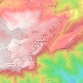
Name: Topografische Karte Kodaikanal, Höhe, Relief.
Ort: Kodaikanal, Dindigul District, Tamil Nadu, 624100, India (10.19512 77.45383 10.27512 77.53383)
Durchschnittliche Höhe: 1.763 m
Minimale Höhe: 506 m
Maximale Höhe: 2.337 m
Andere topografische Karten
Klicken Sie auf eine Karte, um ihre Topografie, ihre Höhe und ihr Relief anzuzeigen.
Kodaikanal Solar Observatory
India > Tamil Nadu > Kodaikanal > Kodaikanal
Durchschnittliche Höhe: 2.238 m