
Topografische Karte La Marque
Interaktive Karte
Klicken Sie auf die Karte, um die Höhe anzuzeigen.
Über diese Karte
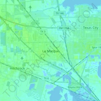
Name: Topografische Karte La Marque, Höhe, Relief.
Ort: La Marque, Galveston County, Texas, 77568, United States (29.32713 -95.06456 29.41101 -94.92904)
Durchschnittliche Höhe: 4 m
Minimale Höhe: -9 m
Maximale Höhe: 21 m
Andere topografische Karten
Klicken Sie auf eine Karte, um ihre Topografie, ihre Höhe und ihr Relief anzuzeigen.
Bacliff
United States > Texas > Galveston County
After Hurricane Ike hit Texas in September 2008, Galveston County officials offered a debris removal program to residents in unincorporated areas, including Bacliff. Flooding from hurricane Ike was minimized due in part to Bacliff's relatively high elevation of 16 feet.
Durchschnittliche Höhe: 4 m
San Luis Pass
United States > Texas > Galveston County > Galveston
Tides cause daily variations in topography, and occasionally, storms more drastically change the topography of the pass.
Durchschnittliche Höhe: 0 m
League City
United States > Texas > Galveston County > League City > League City
Durchschnittliche Höhe: 7 m