
Topografische Karte Grand Rapids
Interaktive Karte
Klicken Sie auf die Karte, um die Höhe anzuzeigen.
Über diese Karte
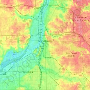
Name: Topografische Karte Grand Rapids, Höhe, Relief.
Ort: Grand Rapids, Kent County, Michigan, United States (42.88365 -85.75153 43.02905 -85.56865)
Durchschnittliche Höhe: 216 m
Minimale Höhe: 178 m
Maximale Höhe: 257 m
Grand Rapids developed on the banks of the Grand River, where there was once a set of rapids, at an altitude of 610 feet (186 m) above sea level. Ships could navigate on the river up to this fall line, stopping because of the rapids. The river valley is flat and narrow, surrounded by steep hills and bluffs. The terrain becomes more rolling hills away from the river. The countryside surrounding the metropolitan area consists of mixed forest and farmland, with large areas of orchards to the northwest. It is approximately 25 mi (40 km) east of Lake Michigan. The state capital of Lansing lies about 60 mi (97 km) to the east-by-southeast, and Kalamazoo is about 50 mi (80 km) to the south.
Andere topografische Karten
Klicken Sie auf eine Karte, um ihre Topografie, ihre Höhe und ihr Relief anzuzeigen.
Richmond Park
United States > Michigan > Kent County > Grand Rapids
Richmond Park, Grand Rapids, Kent County, Michigan, United States
Durchschnittliche Höhe: 202 m
Kent City
United States > Michigan > Kent County
Kent City, Tyrone Township, Kent County, Michigan, United States
Durchschnittliche Höhe: 251 m
Sand Lake
United States > Michigan > Kent County
Sand Lake, Nelson Township, Kent County, Michigan, United States
Durchschnittliche Höhe: 277 m
Comstock Park
United States > Michigan > Kent County > Plainfield Charter Township
Comstock Park, Plainfield Charter Township, Kent County, Michigan, United States
Durchschnittliche Höhe: 206 m
Cascade Charter Township
United States > Michigan > Kent County
Cascade Charter Township, Kent County, Michigan, 49546, United States
Durchschnittliche Höhe: 229 m
Byron Township
United States > Michigan > Kent County
Byron Township, Kent County, Michigan, United States
Durchschnittliche Höhe: 221 m
Creekside Park
United States > Michigan > Kent County > Lowell
Creekside Park, Lowell, Kent County, Michigan, 49331, United States
Durchschnittliche Höhe: 201 m
Sparta
United States > Michigan > Kent County
Sparta, Sparta Township, Kent County, Michigan, United States
Durchschnittliche Höhe: 235 m
Rockford
United States > Michigan > Kent County
Rockford, Kent County, Michigan, 49351, United States
Durchschnittliche Höhe: 239 m
Cedar Springs
United States > Michigan > Kent County
Cedar Springs, Kent County, Michigan, 49319, United States
Durchschnittliche Höhe: 262 m
Sparta Township
United States > Michigan > Kent County
Sparta Township, Kent County, Michigan, 49345, United States
Durchschnittliche Höhe: 246 m
Lowell
United States > Michigan > Kent County
Lowell, Kent County, Michigan, United States
Durchschnittliche Höhe: 206 m
Kentwood
United States > Michigan > Kent County
Kentwood, Kent County, Michigan, United States
Durchschnittliche Höhe: 216 m