
Topografische Karte Karnataka
Interaktive Karte
Klicken Sie auf die Karte, um die Höhe anzuzeigen.
Über diese Karte
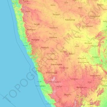
Name: Topografische Karte Karnataka, Höhe, Relief.
Ort: Karnataka, India (11.59456 74.05439 18.47665 78.58808)
Durchschnittliche Höhe: 386 m
Minimale Höhe: -1 m
Maximale Höhe: 1.771 m
The bulk of the state is in the Bayaluseeme region, the northern part of which is the second-largest arid region in India. The highest point in Karnataka is the Mullayanagiri hills in Chikmagalur district which has an altitude of 1,925 metres (6,316 ft). The two main river systems of the state are the Krishna and its tributaries, the Bhima, Ghataprabha, Vedavathi, Malaprabha and Tungabhadra in North Karnataka, and the Kaveri and its tributaries, the Hemavati, Shimsha, Arkavati, Lakshmana Thirtha and Kabini, in South Karnataka. Most of these rivers flow out of Karnataka eastward, reaching the sea at the Bay of Bengal. Other prominent rivers such as the Sharavati in Shimoga and Netravati in Dakshina Kannada flow westward, reaching the sea at the Arabian Sea. A large number of dams and reservoirs are constructed across these rivers which richly add to the irrigation and hydroelectricity power generation capacities of the state.
Andere topografische Karten
Klicken Sie auf eine Karte, um ihre Topografie, ihre Höhe und ihr Relief anzuzeigen.
Bengaluru
India > Karnataka > Bangalore North
Bengaluru, Bangalore North, Bengaluru Urban District, Karnataka, India
Durchschnittliche Höhe: 881 m
Chennai
India > Tamil Nadu > Chennai
Chennai, Chennai District, Tamil Nadu, India
Durchschnittliche Höhe: 8 m
3d
India > Rajasthan > Ganganagar Tehsil > 1 LNP
3d, 1 LNP, Ganganagar Tehsil, Sri Ganganagar District, Rajasthan, India
Durchschnittliche Höhe: 178 m
North Sentinel Island
India > Andaman and Nicobar Islands > Ferrargunj
North Sentinel Island, Ferrargunj, South Andaman District, Andaman and Nicobar Islands, India
Durchschnittliche Höhe: 20 m
Kottakombur
Kottakombur, Devikulam, Idukki District, Kerala, India
Durchschnittliche Höhe: 1.919 m
Prayagraj
India > Uttar Pradesh > Prayagraj
Prayagraj, Prayagraj District, Uttar Pradesh, 211001, India
Durchschnittliche Höhe: 91 m
Kodaikanal
Kodaikanal, Dindigul District, Tamil Nadu, India
Durchschnittliche Höhe: 869 m
Gurgaon
India > Haryana > Gurugram District
Gurgaon, Gurugram District, Haryana, India
Durchschnittliche Höhe: 237 m
Mat
India > Uttar Pradesh > Mathura District
Mat, Mathura District, Uttar Pradesh, India
Durchschnittliche Höhe: 182 m
Mysuru
India > Karnataka > Mysuru taluk
Mysuru, Mysuru taluk, Mysuru District, Karnataka, 570001, India
Durchschnittliche Höhe: 727 m
Akpa
India > Himachal Pradesh > Moorang
Akpa, Moorang, Kinnaur District, Himachal Pradesh, 172116, India
Durchschnittliche Höhe: 2.709 m
Bachupally mandal
Bachupally mandal, Medchal–Malkajgiri District, Telangana, 500090, India
Durchschnittliche Höhe: 593 m
Western Ghats
Western Ghats, Idukki, Kerala, 685614, India
Durchschnittliche Höhe: 2.225 m
Maduranthakam
Maduranthakam, Chengalpattu District, Tamil Nadu, India
Durchschnittliche Höhe: 37 m
Thiruvananthapuram
India > Kerala > Thiruvananthapuram
Thiruvananthapuram, Thiruvananthapuram District, Kerala, 695001, India
Durchschnittliche Höhe: 33 m
Vijayawada
India > Andhra Pradesh > Vijayawada (Urban)
Vijayawada, Vijayawada (Urban), NTR District, Andhra Pradesh, 520001, India
Durchschnittliche Höhe: 36 m
Indore
India > Madhya Pradesh > Juni Indore Tahsil
Indore, Juni Indore Tahsil, Indore District, Madhya Pradesh, 452001, India
Durchschnittliche Höhe: 555 m
Pune
India > Maharashtra > Pune City > Pune
Pune, Pune City, Pune District, Maharashtra, 411001, India
Durchschnittliche Höhe: 641 m
Walmara
India > Uttarakhand > Syalde
Walmara, Syalde, Almora District, Uttarakhand, 263661, India
Durchschnittliche Höhe: 1.043 m
Thuneri
India > Tamil Nadu > Udhagamandalam
Thuneri, Udhagamandalam, Nilgiris District, Tamil Nadu, 643402, India
Durchschnittliche Höhe: 1.899 m
Tharangambadi
Tharangambadi, Mayiladuthurai District, Tamil Nadu, India
Durchschnittliche Höhe: 5 m
Chennai
Chennai, Chennai District, Tamil Nadu, 600001, India
Durchschnittliche Höhe: 7 m
Hosur
India > Tamil Nadu > Hosur
Hosur, Krishnagiri District, Tamil Nadu, 635109, India
Durchschnittliche Höhe: 859 m