
Topografische Karte Austin
Interaktive Karte
Klicken Sie auf die Karte, um die Höhe anzuzeigen.
Über diese Karte
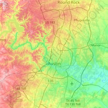
Name: Topografische Karte Austin, Höhe, Relief.
Ort: Austin, Travis County, Texas, United States (30.09851 -97.93677 30.51663 -97.56053)
Durchschnittliche Höhe: 216 m
Minimale Höhe: 113 m
Maximale Höhe: 386 m
The elevation of Austin varies from 425 feet (130 m) to approximately 1,000 feet (305 m) above sea level. Due to the fact it straddles the Balcones Fault, much of the eastern part of the city is flat, with heavy clay and loam soils, whereas the western part and western suburbs consist of rolling hills on the edge of the Texas Hill Country. Because the hills to the west are primarily limestone rock with a thin covering of topsoil, portions of the city are frequently subjected to flash floods from the runoff caused by thunderstorms. To help control this runoff and to generate hydroelectric power, the Lower Colorado River Authority operates a series of dams that form the Texas Highland Lakes. The lakes also provide venues for boating, swimming, and other forms of recreation within several parks on the lake shores.
Andere topografische Karten
Klicken Sie auf eine Karte, um ihre Topografie, ihre Höhe und ihr Relief anzuzeigen.
Mount Lucas
United States > Texas > Travis County > Austin
Mount Lucas, Austin, Travis County, Texas, 78731, United States
Durchschnittliche Höhe: 196 m
Canturbury Trails Park
United States > Texas > Travis County > Austin
Canturbury Trails Park, Austin, Travis County, Texas, United States
Durchschnittliche Höhe: 210 m
Mount Bonnell
United States > Texas > Travis County > Austin
Mount Bonnell, Austin, Travis County, Texas, 78731, United States
Durchschnittliche Höhe: 189 m
Lakeway
United States > Texas > Travis County
Lakeway, Travis County, Texas, United States
Durchschnittliche Höhe: 262 m
Lake Austin
United States > Texas > Travis County > Austin
Lake Austin, Austin, Travis County, Texas, United States
Durchschnittliche Höhe: 242 m
Jonestown
United States > Texas > Travis County
Jonestown, Travis County, Texas, United States
Durchschnittliche Höhe: 276 m
Barton Creek Greenbelt
United States > Texas > Travis County > Austin
Barton Creek Greenbelt, Austin, Travis County, Texas, 78746, United States
Durchschnittliche Höhe: 196 m
Rollingwood
United States > Texas > Travis County
Rollingwood, Travis County, Texas, United States
Durchschnittliche Höhe: 176 m
Bee Cave
United States > Texas > Travis County
Bee Cave, Travis County, Texas, United States
Durchschnittliche Höhe: 270 m
Lake Travis
United States > Texas > Travis County > Lago Vista
Lake Travis, Lago Vista, Travis County, Texas, United States
Durchschnittliche Höhe: 278 m
Steiner Ranch
United States > Texas > Travis County
Steiner Ranch, Travis County, Texas, 78732, United States
Durchschnittliche Höhe: 221 m
Lago Vista
United States > Texas > Travis County
Lago Vista, Travis County, Texas, United States
Durchschnittliche Höhe: 251 m
Austin
United States > Texas > Travis County > Austin
Austin, Travis County, Texas, 78701, United States
Durchschnittliche Höhe: 203 m
Pflugerville
United States > Texas > Travis County > Pflugerville > Pflugerville
Pflugerville, Travis County, Texas, 78691, United States
Durchschnittliche Höhe: 219 m
Pflugerville
United States > Texas > Travis County
Pflugerville, Travis County, Texas, United States
Durchschnittliche Höhe: 215 m