
Topografische Karte North Carolina
Interaktive Karte
Klicken Sie auf die Karte, um die Höhe anzuzeigen.
Über diese Karte
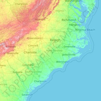
Name: Topografische Karte North Carolina, Höhe, Relief.
Ort: North Carolina, United States (33.75288 -84.32183 36.58816 -75.40012)
Durchschnittliche Höhe: 163 m
Minimale Höhe: -3 m
Maximale Höhe: 1.945 m
North Carolina is defined by a wide range of elevations and landscapes. From west to east, North Carolina's elevation descends from the Appalachian Mountains to the Piedmont and Atlantic coastal plain. North Carolina's Mount Mitchell at 6,684 feet (2,037 m) is the highest point in North America east of the Mississippi River. Most of the state falls in the humid subtropical climate zone; however, the western, mountainous part of the state has a subtropical highland climate.
Andere topografische Karten
Klicken Sie auf eine Karte, um ihre Topografie, ihre Höhe und ihr Relief anzuzeigen.
Los Angeles
Los Angeles, California, United States
Durchschnittliche Höhe: 241 m
New Orleans
United States > Louisiana > Orleans Parish
New Orleans, Orleans Parish, Louisiana, United States
Durchschnittliche Höhe: 1 m
Brooklyn
United States > New York > New York
Brooklyn, Kings County, New York, United States
Durchschnittliche Höhe: 9 m
Albuquerque
United States > New Mexico > Bernalillo County
Albuquerque, Bernalillo County, New Mexico, United States
Durchschnittliche Höhe: 1.688 m
Queens County
United States > New York > New York
Queens County, New York, United States
Durchschnittliche Höhe: 11 m
Madison
United States > Wisconsin > Dane County
Madison, Dane County, Wisconsin, United States
Durchschnittliche Höhe: 284 m
Houston
United States > Texas > Harris County
Houston, Harris County, Texas, United States
Durchschnittliche Höhe: 25 m
Appalachian Mountains
United States > North Carolina > Yancey County
Appalachian Mountains, Yancey County, North Carolina, United States
Durchschnittliche Höhe: 1.463 m
Palm Beach County
Palm Beach County, Florida, United States
Durchschnittliche Höhe: 5 m
Boulder
United States > Colorado > Boulder County
Boulder, Boulder County, Colorado, United States
Durchschnittliche Höhe: 1.785 m
Worcester
United States > Massachusetts > Worcester County
Worcester, Worcester County, Massachusetts, United States
Durchschnittliche Höhe: 186 m
Baltimore
United States > Maryland > Baltimore
Baltimore, Maryland, 21233, United States
Durchschnittliche Höhe: 65 m
Brunswick County
United States > North Carolina
Brunswick County, North Carolina, United States
Durchschnittliche Höhe: 9 m
Sacramento
United States > California > Sacramento County
Sacramento, Sacramento County, California, United States
Durchschnittliche Höhe: 10 m
Staten Island
United States > New York > New York
Staten Island, Richmond County, New York, United States
Durchschnittliche Höhe: 9 m
Spokane
United States > Washington > Spokane County
Spokane, Spokane County, Washington, United States
Durchschnittliche Höhe: 655 m
Indianapolis
United States > Indiana > Indianapolis
Indianapolis, Marion County, Indiana, 46204, United States
Durchschnittliche Höhe: 241 m
Puget Sound
United States > Washington > Edmonds
Puget Sound, Admiral Way, Edmonds, Snohomish County, Washington, 98020, United States
Durchschnittliche Höhe: 0 m