
Topografische Karte College Station
Interaktive Karte
Klicken Sie auf die Karte, um die Höhe anzuzeigen.
Über diese Karte
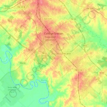
Name: Topografische Karte College Station, Höhe, Relief.
Ort: College Station, Brazos County, Texas, United States (30.51648 -96.38765 30.65841 -96.19656)
Durchschnittliche Höhe: 87 m
Minimale Höhe: 55 m
Maximale Höhe: 119 m
Andere topografische Karten
Klicken Sie auf eine Karte, um ihre Topografie, ihre Höhe und ihr Relief anzuzeigen.
John Crompton Park
United States > Texas > Brazos County > College Station
John Crompton Park, Fox Run Condominiums, College Station, Brazos County, Texas, 77840, United States
Durchschnittliche Höhe: 96 m
Bryan
United States > Texas > Brazos County > Bryan
Bryan, Brazos County, Texas, 77803, United States
Durchschnittliche Höhe: 89 m
Wixon Valley
United States > Texas > Brazos County
Wixon Valley, Brazos County, Texas, United States
Durchschnittliche Höhe: 99 m
College Station
United States > Texas > Brazos County > College Station
College Station, Brazos County, Texas, 77845-5357, United States
Durchschnittliche Höhe: 82 m
Moore
United States > Texas > Brazos County > Wixon Valley
Moore, Wixon Valley, Brazos County, Texas, 77808, United States
Durchschnittliche Höhe: 101 m
Bryan
United States > Texas > Brazos County
Bryan, Brazos County, Texas, United States
Durchschnittliche Höhe: 94 m
Carter Lake
United States > Texas > Brazos County > College Station
Carter Lake, College Station, Brazos County, Texas, United States
Durchschnittliche Höhe: 77 m