
Topografische Karte Mount Afadja
Interaktive Karte
Klicken Sie auf die Karte, um die Höhe anzuzeigen.
Über diese Karte
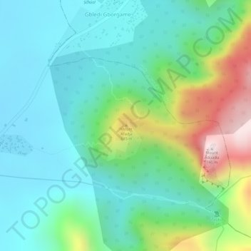
Name: Topografische Karte Mount Afadja, Höhe, Relief.
Ort: Mount Afadja, Volta Region, Ghana (7.02212 0.56180 7.02222 0.56190)
Durchschnittliche Höhe: 371 m
Minimale Höhe: 220 m
Maximale Höhe: 747 m
Andere topografische Karten
Klicken Sie auf eine Karte, um ihre Topografie, ihre Höhe und ihr Relief anzuzeigen.
Keta
Ghana > Volta Region > Keta Municipal District
Keta, Keta Municipal District, Volta Region, VK-0033-1041, Ghana
Durchschnittliche Höhe: 0 m
Ave Dakpa
Ghana > Volta Region > Akatsi North District
Ave Dakpa, Akatsi North District, Volta Region, Ghana
Durchschnittliche Höhe: 94 m
Anfoega
Ghana > Volta Region > North Dayi District
Anfoega, North Dayi District, Volta Region, Ghana
Durchschnittliche Höhe: 160 m