
Topografische Karte Alto Boquete
Interaktive Karte
Klicken Sie auf die Karte, um die Höhe anzuzeigen.
Über diese Karte
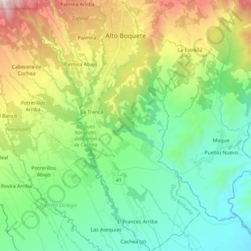
Name: Topografische Karte Alto Boquete, Höhe, Relief.
Ort: Alto Boquete, Distrito Boquete, Chiriquí, Panamá (8.59493 -82.46253 8.76128 -82.37982)
Durchschnittliche Höhe: 713 m
Minimale Höhe: 204 m
Maximale Höhe: 1.880 m
Andere topografische Karten
Klicken Sie auf eine Karte, um ihre Topografie, ihre Höhe und ihr Relief anzuzeigen.
Callejón Seco
Panamá > Chiriquí > Distrito Boquete > Alto Quiel
Callejón Seco, Alto Quiel, Los Naranjos, Distrito Boquete, Chiriquí, 0413, Panamá
Durchschnittliche Höhe: 1.465 m
Alto Lino
Panamá > Chiriquí > Distrito Boquete
Alto Lino, Los Naranjos, Distrito Boquete, Chiriquí, Panamá
Durchschnittliche Höhe: 1.320 m
Volcancito
Panamá > Chiriquí > Distrito Boquete > Bajo Boquete
Volcancito, Bajo Boquete, Distrito Boquete, Chiriquí, Panamá
Durchschnittliche Höhe: 1.255 m
Alto Chiquero
Panamá > Chiriquí > Distrito Boquete > Los Naranjos
Alto Chiquero, Los Naranjos, Distrito Boquete, Chiriquí, Panamá
Durchschnittliche Höhe: 1.954 m
Rock Climbing
Panamá > Chiriquí > Distrito Boquete > Los Naranjos
Rock Climbing, Los Naranjos, Distrito Boquete, Chiriquí, Panamá
Durchschnittliche Höhe: 1.380 m
Palo Alto
Panamá > Chiriquí > Distrito Boquete > Palo Alto
Palo Alto, Los Naranjos, Distrito Boquete, Chiriquí, Panamá
Durchschnittliche Höhe: 1.363 m
Cerro Azul
Panamá > Chiriquí > Distrito Boquete > Jaramillo
Cerro Azul, Jaramillo, Distrito Boquete, Chiriquí, Panamá
Durchschnittliche Höhe: 2.052 m
Los Naranjos
Panamá > Chiriquí > Distrito Boquete
Los Naranjos, Distrito Boquete, Chiriquí, Panamá
Durchschnittliche Höhe: 1.646 m