
Topografische Karte Bir
Interaktive Karte
Klicken Sie auf die Karte, um die Höhe anzuzeigen.
Über diese Karte
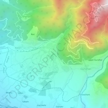
Name: Topografische Karte Bir, Höhe, Relief.
Durchschnittliche Höhe: 1.628 m
Minimale Höhe: 1.284 m
Maximale Höhe: 2.560 m
The paragliding launch site is in the meadow at Billing (14 km north of Bir), at an elevation of 2400 meters, while the landing site and most tourist accommodations are in the village of Chowgan (also spelled Chaugan), on the southern edge of Bir.
Andere topografische Karten
Klicken Sie auf eine Karte, um ihre Topografie, ihre Höhe und ihr Relief anzuzeigen.
Phatt
India > Himachal Pradesh > Baijnath > Kotli
Phatt, Kotli, Baijnath, Kangra District, Himachal Pradesh, 176077, India
Durchschnittliche Höhe: 1.569 m
sakri khas
India > Himachal Pradesh > Baijnath > Langhu
sakri khas, Langhu, Baijnath, Kangra, Himachal Pradesh, 176128, India
Durchschnittliche Höhe: 900 m